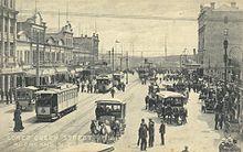
Queen Street, Auckland
The northern end is at Queens Wharf on the Auckland waterfront, adjacent to the Britomart Transport Centre and the Downtown Ferry Terminal.
[1] The early route of Queen Street led up the middle of a gully following the bank of the Waihorotiu Stream (later bounded in as the 'Ligar Canal').
[citation needed] There are several other 'Queen Streets' in the greater Auckland area, mostly in suburbs that were separate towns before being absorbed by a growing central city.
[9] In 1841 colonial settlers built a number of wooden buildings along the western side, following the general path of the Waihorotiu Stream according to the plans set out by surveyor Felton Mathew.
[10] Queen Street riots occurred after a 1932 unemployment march and broke out again in the adjacent Aotea Square in late 1984.
[citation needed] The street has been the site of numerous parades, marches and other events of political, cultural or sporting nature.
[14] An editorial of The New Zealand Herald accused Council of using overestimated public transport user numbers for political purposes to support its bus lane plans.
[citation needed] Public perception in the early 2000s was that Queen Street had lost some of its good reputation in the previous decades, with a rundown and uncoordinated[17] streetscape and the loss of several prestigious retailers cited as either causes or effects.
New street furniture (such as multi-purpose poles for lighting, signage and pennants) and new trees and other landscaping were added to create a 'boulevard effect'.
[18] The liquidambars and Nīkau Palms chosen for the new design touched off heated public discussion in 2006 as their inclusion came at the destruction of previous, established trees (which were not native flora of New Zealand, and thus not retained in the new landscaping plan).
[20] While Council noted in June 2007 that progress had often been quicker than expected,[21] the cost overruns, and the long duration of the construction works – which substantially affected pedestrian and motor vehicle traffic as well as retail sales[22] – made the upgrade unpopular in public, at least during the duration.
[citation needed] The upgrade is now considered to have generally been a success, and it won the 2009 Urban Design Award of the New Zealand Institute of Architects, which commended it for creating a quality public realm and sense of place.
[18][23][25] On 20 July 2023, a mass shooting involving a construction site on the northern end of Queen Street occurred, resulting in the deaths of three people, including the shooter.
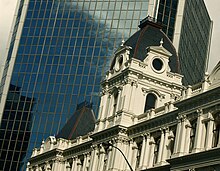
Many large corporations, insurance companies and banks had substantial buildings on Queen Street and in some cases their head offices were located here rather than in Wellington (the capital).
Here are located most of the important civic buildings, including the: Further up Queen Street beyond Mayoral Drive is the uptown district, centred on Myers Park.
The most significant buildings in this area are the: Beyond the Karangahape Road ridge the southernmost 500 metres of the street is called Upper Queen Street, and it crosses the eastern part of the Central Motorway Junction, the largest interchange on the New Zealand state highway network.