Transportation in Edmonton
Transport in Edmonton is fairly typical for a Canadian city of its size, involving air, rail, road and public transit.
With very few natural barriers to growth and largely flat to gently rolling terrain bisected by a deep river valley, the city of Edmonton has expanded to cover an area of nearly 768 km2 (297 sq mi), of which only two-thirds is built-up, while the metropolitan area covers around 9,430 km2 (3,640 sq mi).
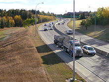
This has resulted in a heavily private transportation-oriented transportation network typical of any other city of its size in North America.
In 1978, Edmonton became the first city with a population of under one million to operate a light rail transit (LRT) system in North America.
A two-stop Capital Line extension to the Heritage Valley Transit Centre was under construction as well.
Edmonton was one of two cities in Canada (the other is Vancouver) that operated a trolley bus system until service was discontinued in May 2009.
Edmonton is connected to British Columbia and Saskatchewan via the Yellowhead Highway (Highway 16, or Yellowhead Trail within city limits), and to Calgary and Red Deer via the Queen Elizabeth II Highway (known as Calgary Trail (southbound) or Gateway Boulevard (northbound) within city limits, on the alignment of the former Calgary and Edmonton Trail).
Anthony Henday Drive (Highway 216) is a 78 km (48 mi) ring road encircling the City of Edmonton completed on October 1, 2016.
[4] The remaining 9 km (5.6 mi) leg in the northeast, from Manning Drive to the Yellowhead Highway in east Edmonton, began construction in 2012, and was completed on October 1, 2016.
In 1914, following amalgamation with Strathcona, Edmonton adopted a new street numbering system, which with a few small modifications is still in use.
Quadrant Avenue (1 Avenue; only constructed west of the river) and Meridian Street (0 Street) divide the city into four quadrants: northwest (NW), southwest (SW), northeast (NE) and southeast (SE).
The city's emergency services, however, have begun to encourage residents to get into the habit of using quadrants in all addresses.
Edmonton is located geographically closer to many destinations in Europe and Asia than the airports in Calgary, Vancouver, Winnipeg as well as points in Western United States.
[9] Edmonton railway station is served by Via Rail trains on their transcontinental service The Canadian.
The High Level Bridge, formerly CPR's route into the downtown, is used in the summer for historical streetcars.