Transportation in Omaha
Transportation in Omaha, Nebraska, includes most major modes, such as pedestrian, bicycle, automobile, bus, train and airplane.
The historic head of several important emigrant trails and the First transcontinental railroad, its center as a national transportation hub earned Omaha the nickname "Gate City of the West" as early as the 1860s.
Transit workers wanted to unionize, and with the main company's management against any effort to change Omaha's reputation as a non-unionized city.
After the introduction of buses in the early 1950s, streetcars were closed down, and in the last years of the decade the city began construction on its components in the Interstate Highway System.
The city has a section of the Lincoln Highway listed on the National Register of Historic Places, and there are more than 100 miles (160 km) of Interstate and freeway lanes, more than any other area in the state of Nebraska.
[4] In 1804, fifty years before the city of Omaha was founded, the Lewis and Clark Expedition first arrived via the Missouri River.
The Expedition's craft, the Western Engineer, was the first steamboat to successfully venture up the Missouri River to the Omaha-Council Bluffs area.
In 1853 William D. Brown had the first vision for the city, leading him to found the Lone Tree Ferry crossing the Missouri River from Council Bluffs, Iowa.
Large steamboats would carry provisions up the Missouri from St. Louis, stocking the warehouses in Jobbers Canyon and loading the trains of the Union Pacific and at the Omaha Quartermaster Depot, which in turn supplied the U.S. Army's Department of the Platte.
Along with local financier Edward Creighton,[1] George Francis Train was the promoter who was mostly responsible for the city landing the railroad.
On rainy days stagecoaches would sink up to their hubcaps, and residents wore knee-high boots to wade through the mud, and at times rivers ran through the streets.
[13] In 1867 Ezra Millard, Andrew J. Hanscom, and Augustus Kountze formed the Omaha Horse Railway Company to provide horsecar service in the city.
By 1886 the city had 44 miles (71 km) of paved streets, including asphaltum, Colorado sandstone, Sioux Falls granite and wooden blocks.
[clarification needed][18] The Saddle Creek Underpass, over which is the Dodge Street Overpass, was completed in 1934 by the Works Progress Administration.
Over 1,175 cubic yards (898 m3) of dirt were excavated to lower Saddle Creek Road sufficiently to pass under the overpass, which is still in use today.
Listed on the National Register of Historic Places in 1992,[19] it is part of the Bridges in Nebraska Multiple Property Submission as well.
They included the Omaha and Southwestern Street Railway Company, which provided services to Kountze Place, Dundee, Bemis Park and the Gold Coast neighborhoods.
Strikebreakers were hired, and within four days the company rolled out heavily fortified streetcars, complete with windows covered by heavy wire and armed guards on board.
The city government lost control of the violence and called in the National Guard, which sent 1,800 troops while Governor Robert Cochran declared martial law and ordered the streetcars to stop running.
Operated by that company until the early 1960s, today the Line is largely abandoned, with a section redeveloped into the recreational MoPac Trail.
Major east-west thoroughfares in Omaha include Fort, Ames, Maple, Blondo, Dodge, Pacific, Center, L, Q and Harrison streets.
The first long segment of Interstate 80 in Nebraska to be opened was a fifty-mile section between Dodge Street in Omaha and the West Lincoln interchange in 1961.
Coupled with social unrest in the 1970s, the highway is blamed for causing a 30 percent housing loss and major increase in crime.
The North Freeway also veers from I-480, and in 2005, the Nebraska Department of Roads began a project to bring the I-480/US 75 interchange up to Interstate standards.
U.S. Route 6 crosses into the city from Council Bluffs on I-480, also called the Gerald R. Ford Freeway in honor of the Omaha native son.
US 275 becomes Nebraska Highway 92 after crossing the South Omaha Veterans Memorial Bridge, following Missouri Avenue, which then becomes "L" Street.
Beginning in fall 2007 there will be more than 30 traffic cameras operating on Omaha area freeways, including one at I-80 near Gretna and another on West Dodge near 120th Street.
[33] The Metro Area Transit Authority was created by the Nebraska Legislature, consisting of a five-member board appointed by the mayor and confirmed by Omaha's City Council and the Douglas County Commissioners.
Located at Benson Park, Westroads Mall, and Metro Community College in South Omaha, they are designed to bolster the city's public busing needs.
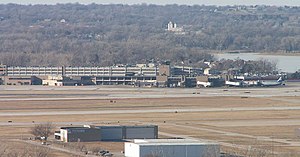
[39] Airlines serving Omaha include Alaska, Allegiant Air, American, Delta, Frontier, Southwest, and United.