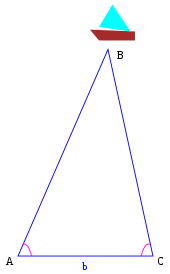
Triangulation
By determining the angles between the projection rays of the sensors and the basis, the intersection point, and thus the 3D coordinate, is calculated from the triangular relations.
Triangulation today is used for many purposes, including surveying, navigation, metrology, astrometry, binocular vision, model rocketry and, in the military, the gun direction, the trajectory and distribution of fire power of weapons.
In the 6th century BC, about 250 years prior to the establishment of the Ptolemaic dynasty, the Greek philosopher Thales is recorded as using similar triangles to estimate the height of the pyramids of ancient Egypt.
Problem 57 of the Rhind papyrus, a thousand years earlier, defines the seqt or seked as the ratio of the run to the rise of a slope, i.e. the reciprocal of gradients as measured today.
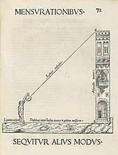
A detailed contemporary collection of constructions for the determination of lengths from a distance using this instrument is known, the Dioptra of Hero of Alexandria (c. 10–70 AD), which survived in Arabic translation; but the knowledge became lost in Europe until in 1615 Snellius, after the work of Eratosthenes, reworked the technique for an attempt to measure the circumference of the earth.