Tropical Storm Beryl (2012)
[1] The second tropical cyclone of the 2012 Atlantic hurricane season, Beryl developed on May 26 from a low-pressure system offshore North Carolina.
Initially subtropical, the storm slowly acquired tropical characteristics as it tracked across warmer sea surface temperatures and within an environment of decreasing vertical wind shear.
It quickly weakened to a tropical depression, dropping heavy rainfall while moving slowly across the southeastern United States.
After forming, Beryl produced rough surf along the southeastern U.S. coast, leaving one person from Folly Beach, South Carolina missing.
In Carteret County, North Carolina, Beryl spawned an EF1 tornado that snapped trees and damaged dozens of homes near Peletier.
While passing over the Cuban Island of Isla de la Juventud, an exposed center of circulation and transient convection was noted due to the effects of high wind shear across the region.
It moved further into the western Atlantic over the next 24 hours, and a band of convection extended across the Bahamas and Cuba to wrap around the southwestern edge of the circulation.
After the system attained gale-force winds near the center and sufficiently organized convection,[1] the NHC initiated advisories on Subtropical Storm Beryl at 0300 UTC on May 26, while the cyclone was 305 mi (490 km) east of Charleston, South Carolina.
Marginally warm waters and dry air were expected to prevent significant intensification,[7] and convection remained minimal through May 26.
[1] The environment near the storm's center became moister and the system began to pass over warmer sea surface temperatures, allowing convection to increase.
[13] It is possible, however, that Beryl briefly reached hurricane intensity early in the evening of May 27 based on Doppler weather radar velocities, although the data is inconclusive according to the post-season report.
[1] At roughly 0410 UTC on May 28 (just after midnight local time), the storm made landfall near Jacksonville Beach, Florida,[14] with winds of about 65 mph (105 km/h) after weakening slightly on the final approach.
[16] As Beryl approached the Atlantic Ocean on May 30, its convection increased to the south and east of the center, although the intrusion of dry air resulted in a ragged appearance on satellite imagery.
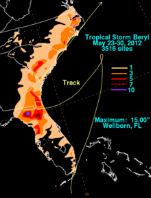
[25] Prior to being classified as a tropical cyclone, the precursor to Beryl produced locally heavy rainfall in South Florida, reaching 9.7 in (250 mm) at Miami International Airport.
[30] A state of emergency was issued in Jacksonville, Florida, causing the early ending of a jazz festival and Memorial Day events.
[31] When Beryl moved ashore, airports around Jacksonville canceled all flights except for JetBlue Airways and Delta Air Lines.
[36] South of Jacksonville, the outer circulation of Beryl spawned a short-lived EF0 tornado in Port Saint Lucie that caused minor damage to two homes.
[38] Just South of Wellborn, a motorcyclist in Taylor County, Florida[39] was killed when a car hydroplaned on the flooded highway and struck him head-on.
[46] In Folly Beach, South Carolina, one person went missing after swimming in rough surf,[47] but it was not included in the overall death toll.
Farther north in Peletier, the storm spawned an EF1 tornado on the Enhanced Fujita scale that damaged 67 homes and destroyed 3 others.

Tropical storm (39–73 mph, 63–118 km/h)
Category 1 (74–95 mph, 119–153 km/h)
Category 2 (96–110 mph, 154–177 km/h)
Category 3 (111–129 mph, 178–208 km/h)
Category 4 (130–156 mph, 209–251 km/h)
Category 5 (≥157 mph, ≥252 km/h)
Unknown