Tropical Storm Bertha (2020)
The National Hurricane Center (NHC) only anticipated slight development as the trough moved over southern Florida, bringing torrential rainfall.
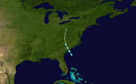
That day, the disturbance developed into Tropical Storm Bertha east of Georgia, and a few hours later it moved ashore near Isle of Palms, South Carolina with peak winds of 50 mph (80 km/h).
As the storm moved into North Carolina, its remnants produced a brief tornado, while rip currents resulted in several water rescues in Surf City.
[5] The NHC estimated that the system developed into Tropical Storm Bertha at 06:00 UTC that day while located about 140 mi (230 km) east of Savannah, Georgia.
The storm quickly weakened as it progressed inland, falling to tropical depression status within a few hours of moving ashore.
[1] The precursor disturbance to Tropical Storm Bertha caused a significant, multi-day rainfall event across South Florida, reaching 8–10 in (200–250 mm) across several locations.
[10] The precursor disturbance spawned an EF1 tornado in Aladdin City, which produced winds of 90 mph (140 km/h) and was on the ground for 4.83 mi (7.77 km).
[13] Local police in El Portal asked that the South Florida Water Management District open floodgates to relieve flooding in those canals.
[17] Unsettled weather related to Bertha forced the cancellation of the planned Crew Dragon Demo-2 launch on May 27 from Cape Canaveral.
[19] Ahead of Bertha's development, the NHC warned of the potential that the system could cause flash flooding, dangerous marine conditions, life-threatening surf and rip currents.
[21] The 2020 Alsco Uniforms 500, held in Charlotte, North Carolina, was also postponed a day due to the possibility of bad weather.
Wrightsville Beach, North Carolina recorded water levels 1.32 ft (0.40 m) above normal, the highest tides related to the storm.
[30] The remnants of Bertha later brought rainfall to West Virginia, resulting in flash flooding in Kanawha County that inundated some roads.
Tropical storm (39–73 mph, 63–118 km/h)
Category 1 (74–95 mph, 119–153 km/h)
Category 2 (96–110 mph, 154–177 km/h)
Category 3 (111–129 mph, 178–208 km/h)
Category 4 (130–156 mph, 209–251 km/h)
Category 5 (≥157 mph, ≥252 km/h)
Unknown

