1954 Atlantic hurricane season
Hurricane Alice developed in the Gulf of Mexico and moved inland along the Rio Grande, producing significant precipitation and record flooding that killed 55 people.
The season officially ended on November 15, although another hurricane named Alice developed on December 30 to the northeast of the Lesser Antilles; it lasted until January 6 of the following year.
[3] Additionally, a group of Hurricane Hunters planes were put on standby for the season, able to be flown out into storms and collect data.
After emerging into the western Atlantic Ocean, a closed circulation developed within the system, and it is estimated that a tropical depression formed on May 28 about 100 mi (160 km) east of Jacksonville, Florida.
Shortly thereafter, the depression intensified into a tropical storm, although the structure was broad and asymmetric due to association with a nearby upper-level low, signaling that the system was possibly a subtropical cyclone.
[12] By June 25, Alice intensified to hurricane status, reaching peak winds of 110 mph (180 km/h) that day, before making landfall in northeastern Mexico, just south of the Mexico–United States border.
This led to significant flooding along the Pecos River that produced "probably the greatest rate of runoff for a watershed of [that] size in the United States", as reported by the International Boundary and Water Commission.
Observations from a coastal lighthouse and a nearby ship indicated that the storm attained peak winds of 50 mph (80 km/h) while moving slowly east-northeastward, just offshore the Carolinas.
[11] On July 27, a tropical depression developed in the northern Gulf of Mexico, about 100 mi (160 km) south of Grand Isle, Louisiana.
[4] A map of the low pressure areas forming in July 1954 indicated that the system originated near the Mississippi Delta and tracked southward.
[6] Officials at the United States Weather Bureau posted a storm warning from Cameron to Burrwood, Louisiana, and also advised small craft to remain at port along the entire northern Gulf Coast.
Moving parallel to the coastline of the southeastern United States, Carol passed just east of Cape Hatteras with winds estimated at 110 mph (180 km/h).
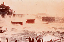
[24] The hurricane moved ashore in Connecticut shortly after high tide, producing a storm surge of 10–15 ft (3.0–4.6 m) from New London eastward.
The surge in Narragansett Bay reached 14.4 ft (4.4 m), which surpassed that of the 1938 New England hurricane, which flooded downtown Providence with 12 feet (3.7 m) of water.
[25] Further north in Maine, Hurricane Carol downed hundreds of trees, as well as destroying widespread apple groves and corn fields.
Weather Bureau noted the potential for Dolly to affect the same areas of New England that Hurricane Carol struck just days prior.
The Hurricane Hunters estimated maximum sustained winds of 85 mph (137 km/h) on September 2 after the storm passed about halfway between the Outer Banks and Bermuda.
[6] As it passed New England, Edna produced a 6 ft (1.8 m) storm surge during a high tide, which caused severe flooding in Martha's Vineyard, Nantucket, and Cape Cod.
The hurricane dropped additional heavy rainfall to areas affected by Carol, resulting in flooding in Massachusetts and Rhode Island.
[30] In Long Island and New England, the hurricane left over $42 million in damage and 20 deaths, only 11 days after Carol affected the same area.
[6][4] Before the storm moved ashore, officials in Veracruz evacuated residents from low-lying areas, and overall about 90,000 people left their homes.
Nearby ship observations indicated that a tropical depression developed the next day in the central Gulf of Mexico, although the system's large structure meant it could have been a subtropical cyclone.
[4][6] While moving just offshore the coast of Honduras, Gilda dropped intense rainfall,[6] which flooding about 680 sq mi (1,800 km2) of land along the Chamelecón and Ulúa rivers.
In response, U.S. Air Force planes flew food, medicine, rafts, and water purification tablets to the most-affected regions.
[6] The storm killed as many as 1,000 people in Haiti before striking the United States near the border between North and South Carolina, as a Category 4 hurricane.
[37] Hazel formed on October 5 just east of the Windward Islands and intensified into a Category 1 hurricane while crossing the southeastern Caribbean Sea.
[38][39] It fluctuated in intensity before making landfall as a Category 4 hurricane in the Carolinas, which destroyed most waterfront dwellings near its point of impact.
[6][41] When Hazel arrived in Ontario, rivers and streams passing through the Greater Toronto Area overflowed their banks, causing severe flooding.
[4] The final storm of the season, Alice, developed on December 30 from a trough of low pressure in the central Atlantic Ocean in an area of unusually favorable conditions.
[53] The practice of retiring the names of particularly deadly or damaging storms from further use in the North Atlantic basin was begun by the United States Weather Bureau following the 1954 season.