Tropical Storm Fay (2002)
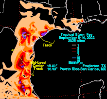
A low pressure center developed along this trough, and on September 5, a Hurricane Hunter aircraft reported that the system had gained sufficient organization to be classified a tropical depression, 95 miles (153 km) southeast of Galveston.
[3] The system weakened rapidly after landfall degenerating into a remnant low on September 8, but the storm's circulation survived for another three days.
[1] The storm caused extremely heavy rainfall in inland areas; damage reached $4.5 million (2002 USD), though there were no fatalities due to Fay.
A low pressure area in the northwest Gulf of Mexico became the dominant circulation and slowly developed persistent convection near the center.
Light wind shear prevented Fay from intensifying further, and the gradual movement was dictated by a weak mid-level ridge to the north.
[4] When the depression was upgraded into Tropical Storm Fay, the warnings were extended from Matagorda, Texas to coastal Louisiana.
[11] Schools closed in Galveston and High Island on September 6 in anticipation of the storm, and voluntary evacuation orders were put into effect along low-lying coastal areas.
[15][16] Along the coast, a waterspout spawned by Fay made landfall, and caused minor damage along the northern end of Galveston Island.
[14] When Fay flooded areas such as Nuevo Laredo, Tamaulipas, 100 families were evacuated from their homes, and 120 people were stranded in hotels.
[20] Nine counties in Texas were declared disaster areas after Tropical Storm Fay: Brazoria, Frio, Galveston, La Salle, Live Oak, Matagorda, Nueces, San Patricio and Wharton.
[21][22] Disaster housing checks handed out after the storm totaled to over $2.7 million (2002 USD) and the Federal Emergency Management Agency (FEMA) had carried out over 2,700 home and building inspections.
[23] After Tropical Storm Fay, the Internal Revenue Service (IRS) announced that they would apply special tax relief for the nine counties in Texas that were declared disaster areas.

Tropical storm (39–73 mph, 63–118 km/h)
Category 1 (74–95 mph, 119–153 km/h)
Category 2 (96–110 mph, 154–177 km/h)
Category 3 (111–129 mph, 178–208 km/h)
Category 4 (130–156 mph, 209–251 km/h)
Category 5 (≥157 mph, ≥252 km/h)
Unknown