Tropical Storm Harvey (1999)
Heavy rainfall was reported in Atlantic Canada and Harvey became the wettest tropical cyclone on record in that country.
Significant flooding, especially to roads and houses, was reported due to the heavy rainfall and damage throughout Atlantic Canada totalled several million dollars.
A tropical wave first emerged from the west coast of Africa on late on September 4, 1999 and entered the Atlantic Ocean.
By September 16 the disturbance transitioned into a broad area of low pressure while tracking northwestward in the western Caribbean Sea.
Thunderstorm activity continued to increase in association with the weather system and a buoy in the eastern Gulf of Mexico recorded sustained winds of 35 mph (56 km/h).
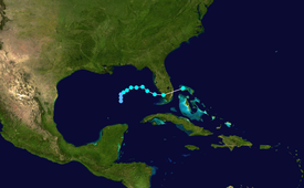
At 0600 UTC on September 19, the system finally developed into Tropical Depression Ten, while located approximately 400 miles (640 km) west-southwest of St. Petersburg, Florida.
[5] Although the center of the storm was poorly defined at the time and located to the northwest of the main area of thunderstorm activity, convection was strong in nature.
Although the remnants of Harvey became unidentifiable later that day,[1] Environment Canada reported that the system crossed Newfoundland before dissipating on September 24.
Tropical storm watches were posted for the state's Atlantic coast north of Jupiter Inlet to near Flagler Beach.
[10] Tropical Storm Harvey dropped moderate to heavy rainfall throughout much of Florida, although the highest amounts were concentrated near its landfall location.
[11] The 4 to 7 inches (100 to 180 mm) of rain in southern Lee County caused minor flooding in homes and businesses in lowly-lying areas, mostly along U.S. Route 41 between Estero and Bonita Springs.
Minor coastal flooding was reported elsewhere, including along the Florida Keys; part of State Road A1A was closed as a result.
[12] The surge combined with increased wave action to produce light beach erosion along the coast and in Everglades National Park.
[1] In Nova Scotia, the remnants of Harvey dropped torrential amounts of rainfall, peaking at 11.89 inches (302 mm) in Oxford.
After two rivers overflowed, at least 70% of Oxford was flooded, which included a hardware store and dozens of homes, while a senior citizens living complex were evacuated.
In the Canning area, 1,500 people were left without power, while electricity was also lost in Annapolis Valley, Yarmouth, Truro, Westville, Amherst, and Stellarton.
In Summerside at least five roads were closed due to flooding and water entered the mechanical room via the telephone and electrical conduit at the local intermediate school.
Adverse conditions also prevented the Northumberland Ferry from docking in Prince Edward Island, causing it to return to Nova Scotia.
[7] The Tropicale, then owned by Carnival Cruise Lines, was left disabled after a fire on board shut down the vessel's engines.
The ship encountered 12 ft (3.7 m) seas in the Gulf of Mexico before restarting one of its engines and taking a path around the storm, having initially planned to return to Tampa.
Tropical storm (39–73 mph, 63–118 km/h)
Category 1 (74–95 mph, 119–153 km/h)
Category 2 (96–110 mph, 154–177 km/h)
Category 3 (111–129 mph, 178–208 km/h)
Category 4 (130–156 mph, 209–251 km/h)
Category 5 (≥157 mph, ≥252 km/h)
Unknown
