Hurricane Dennis (1999)
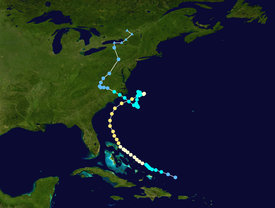
By the following day, steering currents collapsed and the storm interacted with a cold front, causing Dennis to move erratically offshore North Carolina.
By September 4, Dennis turned northwestward and made landfall in Cape Lookout, North Carolina, as a strong tropical storm.
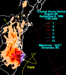
Heavy rainfall produced by the storm in eastern North Carolina was generally beneficial due to drought conditions, but some crops were damaged.
Tracking steadily westward, the wave remained devoid of significant convection until August 21, when associated shower and thunderstorm activity increased a few hundred miles northeast of the Leeward Islands.
Over the course of the next two days, the development of a low-level circulation was noted, though a reconnaissance aircraft failed to locate the presence of a surface low-pressure area on August 23.
Data from a secondary reconnaissance aircraft and ship reports indicated intensification, and the depression was upgraded to Tropical Storm Dennis at 12:00 UTC that same day accordingly.
[1][2] Tracking west-northwestward in advance of a trough over the eastern United States, the system did not resemble a typical hurricane on satellite imagery, with a low-level center outside of the deepest convection.
Following peak intensity, Dennis accelerated towards the northeastward in response to the secondary trough, barely missing the Outer Banks.
By August 31, steering currents collapsed and the hurricane began to aimlessly drift east of Cape Hatteras, North Carolina.
Thereafter, a building ridge over the eastern United States forced the storm southward across slightly warmer ocean temperatures.
A formative eyewall was observed on September 4,[5] and Dennis reached a secondary peak intensity with winds of 70 mph (110 km/h) by 18:00 UTC.
Three hours later, the system moved ashore the Cape Lookout National Seashore in eastern North Carolina at this intensity.
The cyclone drifted erratically even overland, turning northeast and eventually north before dissipating over New York at 18:00 UTC on September 7.
As Dennis began turning northward, the threat of the storm striking Florida lessened, which resulted in discontinuations of the watches and warnings.
[7] As Dennis made its initial approach to North Carolina, state officials urged nearly 150,000 coastal residents to prepare for the storm.
[9] Dennis left $157 million in damage and six deaths, with four in Florida due to drowning in high surf and two in North Carolina as a result of a weather-related car accident.
In South Carolina, numerous weather stations reported winds between 40–55 mph (64–89 km/h) and gusts reaching hurricane force.
[15] Storm surge left three towns on Hatteras Island isolated from the rest of the state as an 8 ft (2.4 m) deep channel was created on North Carolina Highway 12.
Additionally, storm surge cut-off the route between Avon and Buxton and left 4 ft (1.2 m) of sand lying upon portions of Highway 12.
[19] In Beaufort County, storm surge reaching nearly 6 ft (1.8 m) in height flooded portions of the town of Belhaven, including its downtown section.
The rain was generally beneficial as it broke a prolonged dry spell, but it also staged the catastrophic flood disaster caused by Hurricane Floyd a month later.
Combined with swells from Hurricane Dennis, beach erosion, rough surf, and minor tidal flooding battered the coasts of Delaware and New Jersey.
In New Jersey, tides ranged as high as 7.1 ft (2.2 m) above mean lower low water level along the coast, and street flooding was reported onshore.
[16] A narrow band of rainfall produced precipitation rates of over 2 in (51 mm) per hour in some areas across southeastern New York, which resulted in significant street flooding.
[20] In New York City, a period of hot weather, followed by heavy rainfall from the remnants of Dennis, contributed to the formation of a swarm of disease-carrying mosquitoes.
[25] President Bill Clinton approved an emergency declaration for assistance for North Carolina on September 1,[26] as the storm was still offshore.
[29] President Clinton approved a disaster declaration on September 9 for Beaufort, Carteret, Craven, Dare, Hyde, and Pamlico counties in North Carolina.
[30] Within hours of the tornado in Hampton, Virginia, school buses evacuated hundreds of residents of the assisted living facility and apartment complexes to Red Cross shelters.
[32] In Pennsylvania, Dauphin, Lycoming, Northumberland, Snyder, and Union counties also received a disaster declaration on September 22 due to flash flooding associated with Dennis.
[33] Heavy rainfall generated by the storm in North Carolina and Virginia eased a drought in both states, but elevated waterways, setting the stage for disastrous flooding that would occur about two weeks later during Hurricane Floyd.
Tropical storm (39–73 mph, 63–118 km/h)
Category 1 (74–95 mph, 119–153 km/h)
Category 2 (96–110 mph, 154–177 km/h)
Category 3 (111–129 mph, 178–208 km/h)
Category 4 (130–156 mph, 209–251 km/h)
Category 5 (≥157 mph, ≥252 km/h)
Unknown