2003 Atlantic hurricane season
[23] Elsewhere, Hurricane Juan was considered among the most damaging in the history of Halifax, Nova Scotia, where strong winds downed thousands of trees and left low-lying areas flooded from a record storm surge to the city.
It tracked east-southeastward and organized, and on April 21 it transitioned into a tropical cyclone with peak winds of 60 mph (97 km/h), after developing an upper-level warm core.
Increased wind shear caused fluctuations in intensity and a steady weakening trend, and on April 24 the center of Ana merged with an approaching cold front, thus signaling the completion of extratropical transition.
[27] Tracking westward at a low latitude, a disturbance along the wave axis became better organized on June 9,[28] with reasonable favorable environmental conditions for that time of year.
[34] However, the convection subsequently diminished and became displaced to the northeast of the center, and late on June 11 the depression degenerated into an open tropical wave about 950 miles (1,530 km) east-southeast of Barbados.
It slowly organized as it moved northward, and reached a peak of 60 mph (97 km/h) shortly before making landfall 27 miles (43 km) west of Chauvin, Louisiana.
[43] Wind shear increased the next day as the hurricane turned eastward, causing a steady weakening trend that was accelerated after crossing into an area of cooler water temperatures.
[44] After tracking steadily westward, an area of thunderstorms became more concentrated as its upper-level environment became more favorable,[45] and late on July 19 the National Hurricane Center classified it as Tropical Depression Six while it was located about 1,035 miles (1,666 km) east of the Lesser Antilles.
[44] Upon being classified as a tropical cyclone, the depression maintained two ill-defined hooking bands to its north and south, and was originally forecast to attain hurricane status before passing through the Lesser Antilles.
After it passed north of Barbados, a Hurricane hunters flight failed to report a closed low-level circulation, and it is estimated the depression degenerated into an open tropical wave late on July 21.
[53] The depression dropped light to moderate rainfall from Florida to the coast of North Carolina, peaking at 5.17 inches (131 mm) in Savannah, Georgia.
By August 15 its forward motion slowed, allowing the convection to organize into curved rainbands, and late in the day an eye feature began developing.
[55] The hurricane dropped light to moderate rainfall along its path, which caused some flooding; in Montemorelos in Nuevo León, two people died after being swept away by floodwaters.
[58] However, strong southwesterly wind shear unexpectedly became established over the system, and the depression degenerated into a tropical wave late on August 22 to the south of the eastern tip of the Dominican Republic.
Its intensity fluctuated over the subsequent days as it passed north of the Lesser Antilles, and it attained peak winds of 165 mph (266 km/h) on September 11, a Category 5 hurricane on the Saffir–Simpson scale.
The circulation became elongated and separated from the convection as it passed just west of the Cape Verde Islands,[81] where it brought heavy rainfall,[85] and on September 10 the depression dissipated.
[91] Despite the wind shear, Kate continued strengthening as it developed an eye, and the storm attained hurricane status for about 12 hours early on September 29, while located southwest of the Azores.
[89][94] The eye re-appeared occasionally on satellite imagery until early on October 7, when Kate moved over cooler waters, and it weakened to tropical storm status.
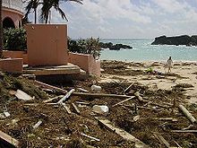
[95] In Atlantic Canada, which was hit by Hurricane Juan weeks prior, officials advised residents to prepare by cleaning debris and securing loose objects.
Due to the expected combination of moisture from Kate and a cold front, the Canadian Hurricane Centre also issued a heavy rainfall warning for southeastern Newfoundland.
[103] The storm caused flooding and mudslides throughout the region, and coincided with the landfall in southwestern Mexico of two Pacific tropical cyclones, Nora and Olaf, adding to the damage.
[110] The rainfall wrecked bridges in Las Piedras and Guayama,[111][112] and led to flooded streams, downed trees, and rockslides that closed four roads.
After the circulation became well-defined near its thunderstorms, a tropical depression formed on October 13 while located 1,030 miles (1,660 km) west-southwest of the Cape Verde islands.
Located within an area of moderate southwesterly wind shear, the depression was slow to organize, strengthening into Tropical Storm Nicholas on October 14.
Shortly after peaking in strength, Nicholas weakened due to increasing southwesterly wind shear, and the center of circulation briefly became exposed from the deep convection.
[118] [119][120][121][122][123] After becoming post-tropical, the remnants of Nicholas executed a large anticyclonic loop, resulting in a westward motion and a brief re-intensification into an extratropical storm on October 29.
On October 30, convection increased over the low-level circulation of what was left to Nicholas, and the National Hurricane Center indicated a potential for tropical or subtropical development as it moved towards warmer waters.
Banding features also increased, and the National Hurricane Center declared the system as Tropical Storm Peter on December 9, about 980 miles (1,580 km) northwest of the Cape Verde islands.
[13] Initially, the National Hurricane Center did not anticipate strengthening;[130] however, Peter intensified to winds of 70 mph (110 km/h) late on December 9, after an eye feature developed.
It turned northward ahead of the same frontal system that absorbed Tropical Storm Odette, and the combination of strong upper-level winds and cooler water temperatures caused quick weakening.