Tropical Storm Thelma
Forming out of a tropical disturbance on November 1, 1991, several hundred kilometers north-northeast of Palau, the depression that would become Thelma tracked generally westward.
After turning southwestward in response to a cold front, the system intensified into a tropical storm on November 4 as it approached the Philippines.
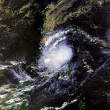
Hours before moving over the Visayas, Thelma attained its peak intensity with estimated ten-minute sustained winds of 75 km/h (45 mph) and a barometric pressure of 992 mbar (hPa; 29.29 inHg).
Despite moving over land, the system weakened only slightly, emerging over the South China Sea on November 6 while retaining gale-force winds.
[nb 1] Initially, it took over 24 hours for word of the disaster to reach officials due to a crippled communication network around Ormoc City.
On October 31, convection associated with the system quickly increased, prompting the issuance of a Tropical Cyclone Formation Alert from the Joint Typhoon Warning Center (JTWC).
[5] Following a satellite-derived surface wind estimate of 45 km/h (30 mph) later that day, the JTWC also began monitoring the low as a tropical depression.
[4] Due to the cyclone's proximity to the country, the Philippine Atmospheric, Geophysical and Astronomical Services Administration also monitored the storm and assigned it with the local name Uring.
[6] Late on November 3, the depression turned west-southwestward towards the Visayas in response to an approaching cold front, an event typical of late-season cyclones in the basin.
Maintaining gale-force winds, the system eventually passed over Palawan Island on November 6 before moving over the South China Sea.
Despite being back over water, strong wind shear prevented re-intensification and caused Thelma to weaken to a tropical depression by November 7.
Now moving westward, the depression eventually made its final landfall over the Mekong River Delta in Southern Vietnam on November 8.
The country's government was reportedly struggling to deal with the scope of the disaster and the addition of Thelma worsened the situation.
The heaviest rain occurred on Leyte Island due to orographic lift, which brought large quantities of moisture into the atmosphere over a relatively small area.
Near the city of Ormoc, a Philippine National Oil Company rain gauge measured 580.5 mm (22.85 in) of precipitation, the highest in relation to the storm.
[13][14] Tropical Storm Thelma devastated the city of Ormoc after torrential rains overwhelmed the Anilao–Malbasag watershed, sending flood waters rushing down the deforested mountainside.
[16] Normally, it takes water in the Anilao and Malbasag rivers roughly 3.6 and 5.6 days, respectively, to reach Ormoc City; however, it only took one hour during the flood.
The turn became the final trigger in the disaster as it created an "instantaneous backwater effect," causing massive volumes of water to over-top the riverbank.
Initially, it took more than 24 hours for word of the level of devastation to reach officials in Manila as communications across Leyte were largely destroyed.
The first shipment of relief supplies, consisting of food rations, rice, sardines, and used clothing, was to be shipped from Cebu later that day.
Amateur radio reports stated that an AC-130 was able to land at a local airport but materials had to be moved by helicopter from there since roads were blocked.
[13] Residents searched through debris for lumber to construct makeshift coffins while others stacked bodies to be picked up by wheelbarrows or trucks.
[22] By November 10, four navy vessels were searching debris in the waters near Ormoc for bodies; 16 were recovered that day with more believed to be submerged in the bay.
[13] Two United States Air Force AC-130s from Subic bay naval base flew to Cebu carrying ready-to-eat meals.
[13] Isle Verde, where approximately 2,300 people were killed, was declared uninhabitable by officials; however, residents still returned to the area due to a need for land.
In a post-disaster assessment in October 1992, it was stated that swift cooperation of all agencies from local to governmental was necessary to prevent tragedies of similar caliber in the future.
Several points were also brought up about rehabilitating the landscape of the watershed: reforestation, contoured farming, and redesigning of plantations to better retain rainwater.
[18] In 1993, following a request by the Philippine Government, the Japan International Cooperation Agency conducted as study on flood control for Ormoc and other cities across the country.
That year, Tropical Depression Auring caused flooding of similar magnitude to Thelma; however, the waters were properly diverted to the sea.
A sculpture and monument to the victims, designed by architect Maribeth Ebcas and artist Florence Cinco respectively, called "Gift of Life" was constructed on a 1.3 km2 (0.50 sq mi) plot of land.

Tropical storm (39–73 mph, 63–118 km/h)
Category 1 (74–95 mph, 119–153 km/h)
Category 2 (96–110 mph, 154–177 km/h)
Category 3 (111–129 mph, 178–208 km/h)
Category 4 (130–156 mph, 209–251 km/h)
Category 5 (≥157 mph, ≥252 km/h)
Unknown