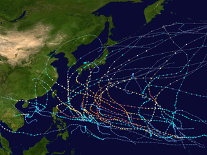
Tropical cyclones in 1997
However, only 89 tropical cyclones were of those attaining 39 mph or greater, falling just below the long term average of 102 named systems.
The accumulated cyclone energy (ACE) index for the 1997 (seven basins combined), as calculated by Colorado State University was 1,099.2 units.
About 150 m (490 ft) below the surface, water temperatures were about 3 °C (5.4 °F) above normal, signifying that an El Niño–Southern Oscillation (ENSO) event was beginning.
The above-average water temperatures covered an area roughly 11,000 km (6,800 mi) across, almost stretching from New Guinea to South America.
[4] By September 1997, the ENSO became very powerful, with surface temperatures between South America and the International Date Line averaging 2–4 °C (3.6–7.2 °F) above normal, roughly a quarter of the planet's diameter.
Additionally, waters along the Pacific coast of North America continued to expand, now stretching from Alaska to southern Mexico.
[6] The Atlantic hurricane season officially began on June 1,[7] and an unnamed subtropical storm developed on the same day.
In August, Tropical Storm Ignacio took an unusual path through the basin, resulting in its extratropical remnants causing minimal damage throughout the Pacific Northwest and California.
Although it never made landfall, it produced large surf in Southern California and as a result, five people had to be rescued.
Hurricane Pauline killed several hundred people and caused record damage in southeastern Mexico.
In addition, Super Typhoons Oliwa and Paka originated in the region before crossing the International Date Line and causing significant damage in the western Pacific.
By May 18 an eye developed and the storm reached its peak intensity with winds of 215 km/h (135 mph) before making landfall near Chittagong.
[22] On September 19, a tropical depression formed from an area of disturbed weather in the western Bay of Bengal.
[23] Typhoon Linda killed 30 while crossing the Malay Peninsula, emerged into the Bay of Bengal on November 4.
[24] A broad trough of low pressure formed into a tropical depression on November 4 in the central Arabian Sea.
Vertical shear weakened it to a depression later that day, but on the 9th, just before making landfall on eastern Somalia, it restrengthened to a tropical storm.
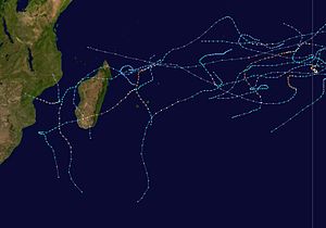
In early December, Cyclone Daniella likely developed out of the remnants of previous Tropical Storm Chantelle.
After reaching peak 10–minute winds of 185 km/h (115 mph), Daniella weakened and passed just southwest of Mauritius; there, the storm left heavy crop damage and indirectly caused three deaths.
Between January and February, Cyclone Pancho-Helinda lasted about 20 days between both the Australian and south-west Indian basins.
Also in February, Tropical Storm Josie killed 36 people in western Madagascar after causing severe flooding.
Despite the early end to the named storms, there were two additional disturbances, one of which became the first July tropical depression in 25 years.
The month began in the South Pacific Ocean with Cyclone Gavin, which recently affected the island nations of Tuvalu and Wallis and Futuna, killing 18 people.
After Gavin dissipated, Cyclone Hina formed on 11 March, causing more than $15.2 million in damage and was indirectly responsible for one death as it affected Tuvalu, Wallis and Futuna, and Tonga.
Cyclone Justin in the Australian region had a long and erratic track, causing widespread damage in Queensland and Papua New Guinea, killing 34 people in total.