Tropical cyclones in 2021
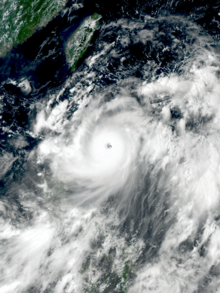
The most intense storm of the year was Typhoon Surigae, with maximum 10-minute sustained wind speeds of 220 km/h (140 mph) and a minimum pressure of 895 hPa (26.43 inHg).
[6] However, following cooler than normal temperatures in the tropical eastern Pacific Ocean, NOAA declared that the global weather conditions shifted back to La Niña by October.
Rhode Island was struck by two tropical systems, Elsa and Henri, an unusual occurrence especially given that the state had recorded no landfalls since Bob in 1991.
[15] Each season dating back to 2016 recorded ACE index values exceeding 129, which senior research associate Brian McNoldy of the University of Miami described as "unprecedented even for four years, let alone six!
Short-lived Victor developed late in the month at an unusually low latitude of 8.1°N, tying Kirk in 2018 and behind only an unnamed 1902 hurricane (7.7°N) for the southernmost location in which an Atlantic system has reached tropical storm intensity.
Wanda remained a tropical cyclone until transitioning into an extratropical low on November 7, which marked the conclusion of activity during the 2021 Atlantic hurricane season.
While Carlos remained away from land, Dolores made landfall on the Mexico coastline and Enrique delivered impacts across southwestern sections of the country while it passed just offshore.
[29] September marked a stark turn around to the activity of the previous months, as it only featured Olaf, which struck San José del Cabo as a Category 2 hurricane.
On the start of October, Tropical storm Lionrock formed east of the Philippines and made landfall on the Chinese Island of Hainan.
In November, Typhon Nyatoh being the only storm of the month formed southeast of Guam and unexpectedly rapidly intensified to a Category 4 super typhoon due to jet interaction.
Ten days later another tropical depression formed in the Bay of Bengal in May 23, before strengthening into a cyclonic storm and receiving the name Yaas.
Four additional tropical lows formed after Kimi, of which one managed to intensify into Cyclone Lucas before crossing into the South Pacific basin on February 3, while the other three had minor effects on land.
On November 29, Teratai formed south of Java Island however the cyclone struggled to develop due to the lack of sufficient outflow.
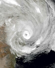
Niran entered the basin on March 5 and caused extensive damage in New Caledonia before accelerating southeast as it transitioned into an extratropical cyclone.
A tropical depression designated as 05 entered the South-West Indian Ocean basin on December 28 and caused a brief interaction with Danilo before dissipating on January 3.
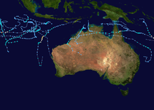
In the Australian region, Cyclone Imogen formed on January 1 and affected Far North Queensland, bringing minimal damage to the area.
Kimi threatened to strike the coast of Queensland, but weakened suddenly due to unexpected wind shear, remaining just offshore instead.
Another system formed on February 10 and made landfall on Mozambique before re-emerging back over water, and was given the name Guambe before reaching tropical cyclone status.
In the Australian region, a tropical low formed before later moving into the South Pacific basin, being designated as 13F; it was short-lived and dissipated on April 11.
In the South-West Indian Ocean, Cyclone Jobo developed near the Seychelles, undergoing a brief period of rapid intensification before dissipating near Tanzania on April 24.
In the South Atlantic, Subtropical Storm Potira formed just off the coast of Rio de Janeiro, causing gale-force winds in Copacabana.
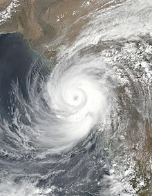
Ten days later, Cyclone Yaas formed in the Bay of Bengal and intensified into a Category 1 equivalent strength, eventually making landfall in northwestern Odisha on May 26.
In the West Pacific, Tropical Storm Koguma formed near Hong Kong and crossed Hainan before making landfall in Vietnam.
Champi formed later in the month, passing close to Guam and the Northern Mariana Islands before recurving out to sea and then intensifying into a typhoon.
In the South Atlantic, Subtropical Storm Raoni formed off the coast of Uruguay, causing some impacts in Montevideo and Punta del Este.
In the Atlantic, (Sub)Tropical Storms Mindy, Odette, Peter, Rose, Teresa, Victor as well as Hurricanes Nicholas and Sam formed.
The West Pacific only featured a super typhoon named Nyatoh which developed near Guam, ending the record-long streak without a major tropical cyclone worldwide since October 3.
At the end of the month, Tropical Cyclone Teratai formed south of Java but struggled to develop due to the lack of outflow.
However, Jawad rapidly weakened due to wind shear shortly after being named, and degenerated into a low-pressure area before it could make landfall over West Bengal.
Rai then entered the South China Sea, re-strengthening into a Category 5 super typhoon east of Vietnam before dissipating near Hong Kong.