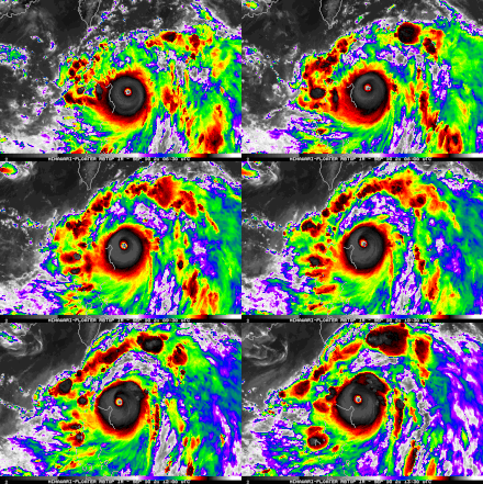
Typhoon Chanthu (2021)
Subsequent eyewall replacement cycles caused intensity fluctuations, but on September 10, Chanthu peaked with 1-minute sustained winds of 285 km/h (180 mph) just northeast of extreme northeastern Luzon.
The storm eventually made its second and final landfall near Ikitsuki, Nagasaki in Japan, before crossing the country's mountainous terrain and becoming an extratropical cyclone on September 18.
[2] At 06:00 UTC on September 5, the JTWC began to monitor an area of disturbed weather that had formed 446 nmi (513 mi; 826 km) from Legazpi, Philippines.
[4] Later in the day, the JTWC issued a Tropical Cyclone Formation Alert as the system's low-level circulation center and its surrounding convection had improved significantly in organization.
[9] At 12:00 UTC, as satellite based intensity estimates from the Dvorak technique increased, the JMA upgraded Chanthu to a severe tropical storm.
[17] However, shortly after, Chanthu quickly re-intensified into a Category 5-equivalent super typhoon yet again at 09:00 UTC that day, as its eye became clear again.
[18] On 05:00 PhST of September 11 (21:00 UTC of September 10), the PAGASA reported that Chanthu passed to the east of the Babuyan Islands;[19] at 08:30 PhST (00:30 UTC), Chanthu made landfall in Ivana, Batanes as a Category 5 super typhoon with 1-minute sustained winds of 270 km/h (165 mph) as the storm began to weaken slightly.
[20][21] At 15:00 UTC on September 11, Chanthu weakened to a Category 4-equivalent typhoon as it continued to move northward because of the presence of dry air.
[22] It was further downgraded to a Category 3-equivalent typhoon by the JTWC on September 12 at 03:00 UTC as it moved towards the east coast of Taiwan, experiencing multiple eyewall replacement cycles, increasing wind shear and dry, stable air.
[25] The weakening trend of Chanthu continued as it moved further northward towards the Korean Peninsula because of increasing wind shear, dry air and cool sea surface temperatures.
[32] Three hours later, the JTWC downgraded Chanthu to a tropical storm as its low-level circulation became partially exposed, with convection only remaining to the north and west.
[34] At 00:00 UTC on September 15, due to decreasing wind shear and marginally favorable sea surface temperatures, Chanthu re-strengthened and was re-classified as a severe tropical storm that day.
[38] At 21:00 UTC, the JTWC downgraded it to a tropical depression as it rapidly collapsed because of the rugged terrain; it was also undergoing extratropical transition.
[47] President of Taiwan, Tsai Ing-wen advised people to stay indoors due to torrential rain and strong winds.
[49] The Batanes Islands suffered a direct hit from Chanthu, which destroyed infrastructure and caused power outages there.
According to the National Disaster Risk Reduction and Management Council (NDRRMC), total damages from the typhoon were up to ₱37.4 million (US$748,000).

Tropical storm (39–73 mph, 63–118 km/h)
Category 1 (74–95 mph, 119–153 km/h)
Category 2 (96–110 mph, 154–177 km/h)
Category 3 (111–129 mph, 178–208 km/h)
Category 4 (130–156 mph, 209–251 km/h)
Category 5 (≥157 mph, ≥252 km/h)
Unknown

