Tropical cyclones in 2023
The North Indian Ocean was unusually active, with six named storms forming, producing the second-most accumulated cyclone energy in this basin on record, only behind 2019.
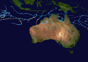
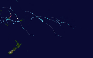
Activity across the southern hemisphere's three basins (South-West Indian, Australian, and South Pacific) was fairly significant, with the regions recording 17 named storms altogether, with the most intense Southern Hemisphere cyclone of the year, Cyclone Kevin in the South Pacific basin, peaking with a central pressure of 913 hPa (26.96 inHg).
[21] They were joined by Tropical Depression Fifteen, later Hurricane Nigel, which formed midway between the Lesser Antilles and Cabo Verde Islands on September 15.
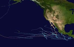
The El Niño event also weakened the Bermuda High, allowing systems to curve northward or take more easterly tracks out to sea, as opposed to being pushed westward towards the continental United States, Mexico, or Central America.
[34] The above-average activity levels were largely attributed to the strong El Niño event, which brought anomalously high sea surface temperatures and low vertical wind shear to western parts of the basin.
[38] On August 11, Dora crossed the International Dateline to become only the second tropical cyclone on record to be at hurricane strength in the Eastern, Central and Western Pacific basins, the other being John in 1994.
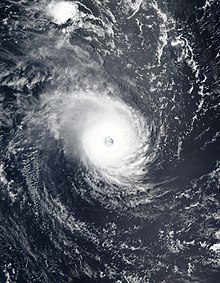
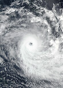
The next day, Mawar completed its eyewall replacement cycle and went on to reach its peak intensity of 295 km/h (185 mph), making it a very strong Category 5-equivalent super typhoon.
As Mawar entered the PAR which was named Betty by PAGASA, it encountered cooler oceans and increasing wind shear which caused it to weaken.
Environmental conditions were marginally favorable to conduct a tropical cyclogenesis, with warm sea temperatures, low vertical wind shear, and good outflow.
While Saola is exhibiting a counter-clockwise loop east of the Philippines, a new broad low-pressure area developed into a tropical depression on August 27, near the Northern Mariana Islands, while slowly drifting westward.
JTWC later issued its last bulletin on Jelawat, stating that land interaction and lack of humidity had made the depression rapidly weaken.
The brown ocean effect caused the cyclone to gradually weaken and was finally downgraded to a well-marked low-pressure area by the IMD on June 19.
Afterward, dry air caused Tej to steadily weaken before making landfall in Al Mahrah Governorate, Yemen.
This system rapidly strengthened into a cyclonic storm, named Midhili, and on November 17, it made landfall near the coast of Bangladesh.
In May, Fabien formed close to the equator and became an intense tropical cyclone, which was unusually strong this late in the season before encountering increasing wind shear.
On January 22, a tropical low classified as 10U by the BoM formed from a monsoon trough over the Arafura Sea, which generally headed westward after formation.
The tropical low that had formed in the Australian region on January 18 crossed over into the South Pacific basin, where the JTWC kept up its TCFA on the system.
On October 19, the Fiji Meteorological Service (FMS) reported that Tropical Disturbance 01F had developed out of an area of low pressure, about 1295 km (805 mi) to the northeast of Honiara in the Solomon Islands.
[73] Although the disturbance was disorganized, it underwent further development due to warm sea surface temperatures and low to moderate vertical wind shear.
[79] As the storm continued to move southeast by the southwest edge of a subtropical ridge, Mal strengthened into a Category 3 severe tropical cyclone at 12:00 UTC of the same day.
The northern part of New Zealand suffered minor flooding after Hale's remnants made landfall over the country on January 10, and one indirect fatality was reported.
In the South-West Indian Ocean basin, Cyclone Cheneso formed south of Diego Garcia and made landfall over northern Madagascar.
In the Southern Indian Ocean basin, a short lived depression classified as 09 formed on March 25 and dissipated two days later without affecting any landmass.
Amang made three landfalls in Southern Luzon before weakening into a remnant low on April 3 due to dry air and wind shear.
In the South-West Indian Ocean basin, a disturbance formed close to the equator on May 12, east of Indonesia and to the south of strengthening Cyclone Mocha.
On June 25, in the Eastern Pacific, a depression formed near the coast of Mexico, which upon strengthening into a tropical storm three days later, was named Adrian.
Soon thereafter, it rapidly intensified, becoming a Category 4 hurricane and tracked westward, where it entered the Central Pacific and passed well south of Hawaii on August 8, with trade winds that may have caused the Maui Fires.
On August 26, Hurricane Idalia formed in the Gulf Of Mexico and rapidly intensified into a Category 4, just like Franklin before making landfall in the Big Bend Region of Florida.
Lee on the other hand, intensified into a Category 5 hurricane over the open Atlantic before making landfall over Nova Scotia, becoming the strongest storm of the month.
Koinu reached its peak intensity as a Category 4 typhoon and passed south of Taiwan before impacting the Pearl River Delta while Yun-yeung brought heavy rainfall across Japan, disrupting several train services.

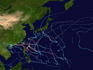
Among them, Mawar (second image in the second row) was the most intense with a minimum central pressure of 900 hPa.