Martin Peninsula
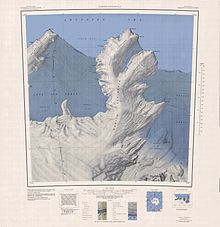
[1] Download coordinates as: The Martin Peninsula extends north from the coast of Marie Byrd Land into the Amundsen Sea.
Glade Bay and Sweeny Inlet are on its west side, which is the eastern limit of the Getz Ice Shelf.
A line of steep ice bluffs that form the southeast side of Philbin Inlet on Martin Peninsula.
Named by US-ACAN for Master Chief Quartermaster James L. Furman, United States Navy, staff assistant assigned to Antarctic Task Force 43 from 1964-67.
An ice-covered promontory rising to about 450 metres (1,480 ft) high between Singer Glacier and Rydelek Icefalls.
Named by US-ACAN in 1977 after William Smythe, geophysicist, University of California, Los Angeles, a member of the USARP winter party at South Pole Station, 1975.
A broad ice-covered area rising over 500 metres (1,600 ft) high and covering some 25 square nautical miles (86 km2; 33 sq mi), located south of McClinton Glacier and west of Mount Bray.
A rounded mountain that is ice-capped but has a steep, bare rock southeast face, situated east of Jenkins Heights and 1.5 nautical miles (2.8 km; 1.7 mi) northwest of Klimov Bluff.
Named by US-ACAN after Thomas K. Bray, USGS topographic engineer with the Marie Byrd Land Survey party, 1966-67.
A glacier flowing east-northeast from Martin Peninsula between Slichter Foreland and Smythe Shoulder into Dotson Ice Shelf.
Named in 1977 by US-ACAN after Howard Singer, geophysicist, University of California, Los Angeles, a member of the USARP winter party at South Pole Station, 1973.
An area of icefalls between Smythe Shoulder and Coyer Point on the east side of Martin Peninsula.
Named by US-ACAN in 1977 after Paul Rydelek, geophysicist, University of California, Los Angeles, a member of the USARP winter party at South Pole Station, 1974.
A glacier between the base of Martin Peninsula and Jenkins Heights, flowing east-northeast into Dotson Ice Shelf.
Named by US-ACAN after Racie A. McClinton, Jr., United States Navy, LC-130 flight engineer of Squadron VXE-6, who served in nine OpDFrz deployments through 1977.
Named by US-ACAN in 1977 after Keith W. Keys, AC1, United States Navy, air controller at Williams Field, McMurdo Sound, 1975-76.
Named by US-ACAN for Lieutenant R.A. Binder, United States Navy, maintenance coordinator at the Williams Field air strip, McMurdo Sound, during Deep Freeze 1967.
Siglin, United States Navy, maintenance coordinator at the Williams Field air strip, McMurdo Sound, during Deep Freeze 1967.
Schneider, United States Navy, maintenance coordinator at the Williams Field air strip, McMurdo Sound, during Deep Freeze 1966.
Carter, United States Navy, maintenance coordinator at the Williams Field air strip on McMurdo Sound during Operation Deep Freeze 1966.
An ice-covered point on the west side of Murray Foreland, Martin Peninsula, 12 nautical miles (22 km; 14 mi) southwest of Cape Herlacher.
Named by US-ACAN in 1955 after Carl J. Herlacher, principal Antarctic cartographer with the United States Navy Hydrographic Office 1937.
Named by US-ACAN after Commander Glen Jacobsen, United States Navy, captain of the icebreaker Atka on the 1954-55 reconnaissance cruise to Antarctica to examine sites for use as science stations during the 1957-58 IGY.
It is the north end of an ice-covered peninsula that extends into Dotson Ice Shelf, 23 nautical miles (43 km; 26 mi) south-southeast of Jacobsen Head.