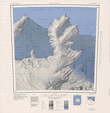
Kohler Range
The range is about 40 nautical miles (74 km; 46 mi) long and stands between the base of Martin Peninsula and Smith Glacier.
It is north of the Smith Glacier, which flows in a northeast direction from Toney Mountain to the Dotson Ice Shelf.
[4] The Kohler Range was discovered from a distance on February 24, 1940 by Rear Admiral Richard E. Byrd and other members of the United States Antarctic Program (USAS) in an airplane flight from the ship Bear.
Byrd named the range after Walter J. Kohler Jr., manufacturer, and former Governor of Wisconsin, who helped furnish the seaplane from which the discovery was made.
A distributary of the Smith Glacier, flowing northward through the middle of the Kohler Range into Dotson Ice Shelf.
Named by US-ACAN for Thomas R. Horrall, USARP glaciologist with the Marie Byrd Land Survey party, 1966-67.
An ice-covered ridge about 12 nautical miles (22 km; 14 mi) long, located west of Horrall Glacier in the northwest part of Kohler Range.
Named by US-ACAN for DeWayne J. Faulkender, USGS topographic engineer with the Marie Byrd Land Survey party, 1966-67.
A cone-shaped, ice-covered peak located 12 nautical miles (22 km; 14 mi) southwest of Morrison Bluff.
Named by US-ACAN after Charles E. Morrison, USGS topographic engineer, who conducted surveys on several USGS Antarctic expeditions, including establishment of the Byrd ice-strain network, 1964–65, and surveys in Marie Byrd Land, 1966–67; in Ellsworth Land, 1968-69; in McMurdo Dry Valleys, 1971-72.
A cluster of rocks located 5 nautical miles (9.3 km; 5.8 mi) north-northwest of Detling Peak in the northwest part of Kohler Range.
A machinery technician assigned to USCGC Glacier, he lost his life in an accident aboard the ship while it was in the Ross Sea enroute from McMurdo Station to the Antarctic Peninsula, January 22, 1976.
A hill 1 nautical mile (1.9 km; 1.2 mi) west of Manfull Ridge on the north side of the Kohler Range.
Named by US-ACAN for Lieutenant Winston Cope, MC, United States Navy Reserve, Medical Officer at the South Pole Station, 1974.
A broad snow-covered ridge that descends gently from the north side of Kohler Range about 5 nautical miles (9.3 km; 5.8 mi) west of Morrison Bluff.
Named by US-ACAN after Geoffrey L. Leister, biologist with the USARP Marie Byrd Land Survey Party, 1966-67.
Named by US-ACAN for Robert T. Slater, EO2, United States Navy, Equipment Operator at the South Pole Station, 1974.
A flattish, mainly ice-covered mountain with steep rock slopes, located 4 nautical miles (7.4 km; 4.6 mi) west-southwest of Mount Strange.
A partly ice-free mountain 4 nautical miles (7.4 km; 4.6 mi) east-northeast of Mount Isherwood, standing at the east side of Simmons Glacier.
Named by US-ACAN for Joe F. Strange, USGS topographic engineer, member of the Marie Byrd Land Survey Party, 1966-67.
A mountain rising to 665 metres (2,182 ft) high near the northeast end of Kohler Range, 3 nautical miles (5.6 km; 3.5 mi) east of Mount Strange.
Named by US-ACAN in 1977 after Tony Kenneth Meunier, cartographer and physical scientist with USGS from 1972; member of USGS satellite surveying team at South Pole Station, winter party, 1974; member of Antarctic Search for Meteorites (ANSMET) team in the Allan Hills area, 1982–83, initiating a plan for positioning, by satellite surveying methods, the location of meteorites discovered in field operations; from 1991, in Polar Programs Section, Office of International Activities, USGS.