Turin Papyrus Map
It is drawn on a papyrus reportedly discovered at Deir el-Medina in Thebes, collected by Bernardino Drovetti (known as Napoleon's Proconsul) in Egypt sometime before 1824 and now preserved in Turin's Museo Egizio.
It was prepared for Ramesses IV's quarrying expedition to the Wadi Hammamat in the Eastern Desert, which exposes Precambrian rocks of the Arabian-Nubian Shield.
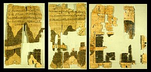
A new and more accurate reconstruction was proposed by Harrell and Brown in 1992, leading to a reduced length of 2.1 m.[1][2][3] Besides being a topographic map of surprisingly modern aspect, the Turin Papyrus is also a geological map (the earliest known) because it accurately shows the local distribution of different rock types (with black and pink hills), the lithologically diverse wadi gravels (with brown, green and white dots), and it contains information on quarrying and mining.
The verso of the papyrus is inscribed with unrelated texts, in particular a letter addressed directly to Ramesses VI and pertaining to a cult statue of his setup in the temple of Hathor in Deir el-Medina.
Harrell notes that "The map was rolled up when discovered and subsequently handled, and this explains the especially poor preservation of the rightmost portion in Figure 3, which formed the outer abraded surface of the scroll.".