Typhoon Betty (1980)
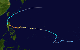
After turning east from south, the disturbance was classified as a tropical storm on October 29 as it passed near Guam, causing only minor damage.
By November 8, Betty, after moving offshore, had completed its transition into an extratropical cyclone, and dissipated that same day.
[2] Five days later, the disturbance began to show signs of organization while it was located to the south of Truk Atoll.
[3] At 00:00 UTC on October 28, the Japan Meteorological Agency (JMA) upgraded the system to a tropical depression.
[7] After moving erratically during its formative stages, Tropical Storm Betty accelerated towards the west-northwest as it passed south of Guam.
[2] On November 1, the Philippine Atmospheric, Geophysical and Astronomical Services Administration (PAGASA) also began to track the storm and assigned it with the local name Aring.
[8] After turning due west,[3] Betty continued to intensify,[2] although a Hurricane Hunter penetration later on November 1 indicated no eyewall.
On November 3, the trough moved quickly eastward north of the system, closing Betty's window for re-curvature.
[3] Following the formation of an eye,[3] the JMA estimated that the typhoon peaked in intensity the next day, with winds of 185 km/h (115 mph) and a barometric pressure of 925 mbar (27.3 inHg).
[2] By 00:00 UTC on November 4, the JTWC amended its forecast for Typhoon Betty, projecting it to move northwest into southern Luzon and China.
[3] Twelve hours later, the JMA ceased tracking the system,[4] while the cyclone was located southeast of Honshu.
[3] During its formative stages, Betty passed near Guam, where strong winds caused major crop damage and downed power lines.
[11] Upon making landfall in the Philippines, press reports indicated that Betty became the strongest typhoon to strike the country in a decade.
Tropical storm (39–73 mph, 63–118 km/h)
Category 1 (74–95 mph, 119–153 km/h)
Category 2 (96–110 mph, 154–177 km/h)
Category 3 (111–129 mph, 178–208 km/h)
Category 4 (130–156 mph, 209–251 km/h)
Category 5 (≥157 mph, ≥252 km/h)
Unknown