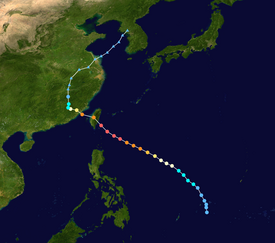
Typhoon Bilis (2000)
The tenth named storm of the season, Bilis originated from an area of disturbed weather that developed into a tropical depression southeast of Guam on August 18.
Without significant inhibiting factors, the typhoon reached its peak intensity with maximum sustained winds of 205 km/h (127 mph) and a minimum barometric pressure of 920 mbar (hPa; 27.17 inHg).
Despite its short stint over land, Bilis was greatly weakened, and made a brief track over the Taiwan Strait before its final landfall on China's Fujian Province early the next day.
The predecessor to Typhoon Bilis began as a developing area of disturbed weather well south-southeast of Guam on August 15.
[1] At 0600 UTC on August 17, the Joint Typhoon Warning Center (JTWC) began classifying the system as a tropical depression.
[3] Tracking northwestward, the favorable conditions allowed the depression to quickly strengthen and attain tightly wrapped rainbands,[1] prompting the JMA to upgrade the system to tropical storm status at 0600 UTC on August 19,[3] thus designating the storm with the name Bilis.
As a result of its rapid intensification, Bilis grew in size, exhibiting a behavior typical of tropical cyclones originating from the northwest Pacific monsoon trough.
[1] Six hours later, the JMA indicated that the typhoon had reached its peak intensity with maximum sustained winds of 205 km/h (127 mph) and a minimum barometric pressure of 920 mbar (hPa; 27.17 inHg).
By this point convection was intermittent and short-lived,[1] and at 1200 UTC the JMA classified the system as a tropical depression.
Bilis' remnants continued to track northeast, across the Yellow Sea, and dissipated on August 27 shortly after entering the Korean Peninsula.
[6] Though the storm had not yet made landfall, one person was killed in Taipei on August 22 after they were buried by a landslide triggered by the impending typhoon; this accounted for the first fatality caused by Bilis.
Taiwanese coast guard members regulated fishing activity due to the threat of deadly wave action.
[1] Preparations for Typhoon Bilis on the Chinese mainland began on August 22, when the Xiamen Meteorological Observatory issued a warning for Fujian Province.
[16] After becoming a tropical cyclone, Bilis' outer rainbands dropped heavy rainfall on Okinawa Prefecture in the Ryukyu Islands.
At Kunsan Air Base, 468 mm (18.4 in) of rain was recorded over a 48-hour period; this two-day total was over three times the August average for the location.
Tropical storm (39–73 mph, 63–118 km/h)
Category 1 (74–95 mph, 119–153 km/h)
Category 2 (96–110 mph, 154–177 km/h)
Category 3 (111–129 mph, 178–208 km/h)
Category 4 (130–156 mph, 209–251 km/h)
Category 5 (≥157 mph, ≥252 km/h)
Unknown
