Typhoon Kirogi (2000)
On July 3, the storm underwent rapid intensification and attained Category 4 status on the Saffir–Simpson Hurricane Scale the next day, according to the JTWC.
On July 5, the Japan Meteorological Agency (JMA) assessed the storm to have reached its peak intensity with 10-minute sustained winds of 155 km/h (100 mph) and a barometric pressure of 940 hPa (27.76 inHg).
Initial news reports stated that Kirogi produced deadly flooding in the Philippines; however, the storm was too far from the country to have any impacts.
In Japan, Kirogi produced torrential rainfall and high winds, killing three people and leaving ¥54.4 billion (2000 JPY, $505 million USD) in damages.
[1] Early on July 5, the JMA reported that Kirogi attained its peak intensity with 10-minute sustained winds of 155 km/h (100 mph) and a barometric pressure of 940 hPa (27.76 inHg).
[1] Several hours after attaining peak intensity on July 5, a mid-level trough caused convection around the center of Kirogi to weaken and the eye became cloud-filled.
[1] Gradual weakening took place as Kirogi tracked towards Japan, with both the JTWC and JMA reporting sustained winds at 140 km/h (85 mph) by July 7.
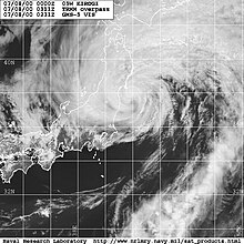
[2][3] Early on July 8, the storm brushed the eastern coast of Japan near Chōshi, Chiba with 10-minute sustained winds of 150 km/h (90 mph).
[2] CNN and the Los Angeles Times reported that the storm produced heavy rainfall in the Philippines, resulting in fatalities.
[7][8] A total of 120 flights were canceled ahead of the storm and 30 ferry services were halted due to rough seas up to 9 m (30 ft).
[11] In the city of Tokyo, Japanese officials ordered 800 residents to evacuate to shelters due to the threat of Typhoon Kirogi.
Throughout Aomori Prefecture, large stretches of roads were washed out by flood waters and several thousand homes were inundated.

Tropical storm (39–73 mph, 63–118 km/h)
Category 1 (74–95 mph, 119–153 km/h)
Category 2 (96–110 mph, 154–177 km/h)
Category 3 (111–129 mph, 178–208 km/h)
Category 4 (130–156 mph, 209–251 km/h)
Category 5 (≥157 mph, ≥252 km/h)
Unknown