Typhoon Hattie
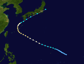
[1][2] Hattie originated from an area of disturbed weather that developed within the Western Pacific monsoon trough towards the end of September.
On October 7, Hattie lost typhoon intensity, and after tracking directly over Tokyo, transitioned into an extratropical cyclone on the next day.
While Typhoon Gene was recurving just offshore Japan, an area of disturbed weather first developed in the Western Pacific monsoon trough 185 km (115 mi) east of Guam.
[4] Additional organization was limited by strong westerly winds aloft,[3] but early on September 30, the Japan Meteorological Agency (JMA) upgraded the disturbance into a tropical depression.
[5][nb 1] Thunderstorm activity subsequently flared up, and an hour later, the JTWC issued a Tropical Cyclone Formation Alert for the disturbance.
Meanwhile, Hattie began to intensify at the climatological rate of one Dvorak T-number per day due to decreased wind shear and improved upper-level outflow.
Thunderstorm activity quickly consolidated around a reformed low-level circulation[3] and the JMA upgraded Hattie into a severe tropical storm on October 2.
Despite a decrease in cloud top temperatures surrounding the eye, normally a sign of weakening, increased Dvorak intensity estimates justified the JTWC raising the intensity of Hattie to 170 km/h (105 mph) at 00:00 UTC on October 4, equal to a mid-grade Category 2 hurricane on the United States-based Saffir-Simpson Hurricane Wind Scale.
[3] Twenty-four hours later, the JMA estimated that Hattie peaked in intensity, with winds of 145 km/h (90 mph) and a barometric pressure of 950 mbar (28 inHg).
[5] On the evening of October 5, Typhoon Hattie began to recurve to the north,[9] rounding the aforementioned ridge[3] after passing through the Ryukyu Islands.
Shower and thunderstorm activity quickly decreased near the center,[3] and both the JTWC and JMA agreed that Hattie lost typhoon intensity on the morning of October 7.
[3] Across Okinawa, power lines were downed in 1,035 spots and agricultural damage totaled to ¥926 million yen, mostly from sugar cane, vegetables, and flowers.
[22] In Kyoto, six train passengers were injured by flying glass when the typhoon's powerful winds toppled trees onto their coach.
Tropical storm (39–73 mph, 63–118 km/h)
Category 1 (74–95 mph, 119–153 km/h)
Category 2 (96–110 mph, 154–177 km/h)
Category 3 (111–129 mph, 178–208 km/h)
Category 4 (130–156 mph, 209–251 km/h)
Category 5 (≥157 mph, ≥252 km/h)
Unknown