Typhoon Irma (1981)
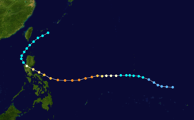
Following an increase in organization, the system was first classified on November 18 and was subsequently upgraded into a tropical storm on the next day as it moved westward.
After passing near Guam, Irma continued to deepen, and was estimated to have attained typhoon intensity early on November 21.
The intensification rate accelerated thereafter, and on the afternoon of November 22, Irma reached its peak wind speed of 205 km/h (125 mph).
After maintaining this intensity for 16 hours, Irma weakened considerably due to interaction with the mountainous terrain of the Philippines.
Irma then began to re-curve towards the northwest while weakening; the cyclone was estimated to have obtained extratropical characteristics on November 26.
Affecting an area already severely impacted by Typhoon Hazen, Irma brought significant damage and flooding to the Philippines, especially in the province of Camarines Norte.
Additionally, a 15 m (50 ft) tidal wave was noted in four towns in the Camarines Sur province, resulting in the deaths of 137 people.
The second of three storms to form within this region in mid-November 1981, the cyclone was first noted on November 10 as a "zone of strong convection activity".
However, a weak circulation was detected on a few days later, and on November 15, the system was situated to the east of Ponape as satellite imagery indicated that convection was developing.
That afternoon, the Joint Typhoon Warning Center (JTWC) issued a Tropical Cyclone Formation Alert (TCFA) for the disturbance.
[2][nb 2] On the morning of November 19, a Hurricane Hunter aircraft reported winds of 55 km/h (35 mph), prompting the JTWC to classify the system as a tropical depression.
[4][nb 3] Around this time, the JTWC expected that Irma would pass south of a front and then turn southwest.
[4] Later that evening, a Hurricane Hunter aircraft reported winds of 160 km/h (100 mph) and a pressure of 968 mbar (28.6 inHg).
[1] Following the formation of a 74 km (46 mi) eye,[1] the JMA declared that Irma attained typhoon status at 0000 UTC on November 21;[2] subsequently, the system passed south of a second cold front.
[6][7] Irma maintained super typhoon intensity for 16 hours before gradually weakening due to the storm's close proximity to the mountainous terrain of the Philippines.
After turning northwest towards a break within the subtropical ridge, Irma moved ashore around 0900 UTC on November 24, roughly 100 km (60 mi) northeast of Manila.
[2][7] A few days prior to Irma's passage, the Philippines archipelago was affected by Typhoon Hazen, which left 2,000 homeless.
[11] A 15 m (50 ft) tidal wave swamped the towns of Garchitorena, Serona, Lagonoy and Caramoan in the Camarines Sur province, situated roughly 230 km (145 mi) southeast of Manila.
[20] Twenty-six of the casualties happened in Manila[11] while 12 others died in the rural town of Daet along the southern part of Luzon due to flooding and falling debris.
In the Rizal province, one agency reported that it dispatched several army trucks to fetch roughly 2,000 stranded 12- to 15-year-old boy scouts.
[23] Philippine President Ferdinand E. Marcos ordered the closure of all government offices in affected areas, which included the capital city of Manila.
Tropical storm (39–73 mph, 63–118 km/h)
Category 1 (74–95 mph, 119–153 km/h)
Category 2 (96–110 mph, 154–177 km/h)
Category 3 (111–129 mph, 178–208 km/h)
Category 4 (130–156 mph, 209–251 km/h)
Category 5 (≥157 mph, ≥252 km/h)
Unknown
