Typhoon Irma (1985)
Typhoon Irma originated from a monsoon trough situated near Guam in the Western Pacific Ocean.
By June 24, organization improved as the system encountered favorable conditions aloft and the disturbance attained tropical storm intensity the next day.
Although Irma stayed offshore the Philippines, moisture associated with the storm inundated areas already affected by Typhoon Hal earlier in the week.
During mid-June 1985, the monsoon trough in the Western Pacific retreated eastward to near Guam, spawning several areas of low pressure.
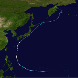
At 00:00 UTC on June 17, a tropical disturbance embedded within the monsoon trough was detected by meteorologists on weather satellite imagery about 400 km (250 mi) southwest of the island of Ponape.
Moving west-northwest south of a ridge, the disturbance passed 180 km (110 mi) south-southeast of the Truk Atoll early on June 18.
Following an increase of thunderstorm activity associated with the disturbance in both coverage and organization, the JTWC issued a Tropical Cyclone Formation Alert (TCFA) for the system at noon the same day.
On the afternoon of June 20, the Hurricane Hunters finally founded a closed circulation, but outflow from nearby Typhoon Hal inhibited further development.
By June 24, however, vertical wind shear had begun to relax, coinciding with an expansion of the storm's southwesterly outflow channel.
[2] At around the same time, the Philippine Atmospheric, Geophysical and Astronomical Services Administration (PAGASA) started to follow the storm and assigned it with the local name Daling.
[1] Irma slowly deepened, and according to the JMA, the system attained a secondary peak intensity of 115 km/h (70 mph) late on June 25.
On June 27, Irma's forward speed slowed as it approached the edge of the subtropical ridge situated along the 130th meridian east[1] while intensifying.
[2] That morning, both the JTWC and the JMA estimated that Irma attained typhoon intensity;[6] this upgraded was primarily based on data from ship reports.
[2] Shortly after its peak, Typhoon Irma began to accelerate towards the northeast in the direction of central Japan in response to westerlies.
[2] Tracking just east of the Ryukyu Islands,[8] Irma began to acquire extratropical characteristics[1] A Hurricane Hunter flight on June 30 suggested that that typhoon was encountering cooler and drier air, although the storm maintained a 55 km (35 mi) eye.
[2] Six hours later, the cyclone completed its extratropical transition[1] near Tokyo;[8] the JTWC issued its final warning on the system.
On July 7, the JMA ceased tracking the system as it had merged with an extratropical low south of the Kamchatka Peninsula.
[10] Even though Typhoon Irma passed well east to the Philippines, over 30 in (710 mm) of rain fell over parts of Luzon.
These rains resulted in major flooding; Irma was also the second storm to directly affect the nation within a week, following Typhoon Hal.
[18] Twenty domestic airline flights were cancelled and 26 railway lines within Tokyo were suspended,[23] leaving 240,000 people stranded.
Tropical storm (39–73 mph, 63–118 km/h)
Category 1 (74–95 mph, 119–153 km/h)
Category 2 (96–110 mph, 154–177 km/h)
Category 3 (111–129 mph, 178–208 km/h)
Category 4 (130–156 mph, 209–251 km/h)
Category 5 (≥157 mph, ≥252 km/h)
Unknown