Typhoon Paka
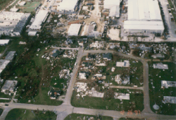
Later, it passed just north of Guam, where strong winds destroyed about 1,500 buildings and damaged 10,000 more; 5,000 people were left homeless, and the island experienced a complete power outage following the typhoon.
As the weather synoptics of the northern Pacific Ocean transitioned into a late-fall to early winter-type pattern, convection from the monsoon trough extended to the east of the International Date Line.
The disturbance gradually organized as it drifted north-northeastward, and on 28 November it developed into Tropical Depression Five-C about 465 km (289 mi) west-northwest of Palmyra Atoll.
It turned to the west on 1 December, due to the presence of a strong anticyclone to its north with a ridge extending westward past the International Date Line.
On 2 December, based on satellite estimates, the CPHC upgraded the depression to Tropical Storm Paka while located about 1,000 km (620 mi) south-southeast of Johnston Atoll.
The next day, however, it encountered dry air and began weakening; by 6 December, the winds had decreased to minimal tropical storm status for about 12 hours.
Subsequently, Paka began to re-intensify, and on 7 December the storm crossed the International Date Line into the western North Pacific Ocean with winds of 80 km/h (50 mph).
Paka continued to intensify after crossing the date line, and from late on 7 December through early the following day it remained a strong tropical storm.
By 10 December, the shear had begun to decrease as the storm moved through the Marshall Islands, and that night the JTWC upgraded Paka to typhoon status.
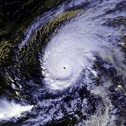
However, Paka again re-intensified, and at 1200 UTC on 14 December it attained the unofficial ranking of Category 5 super typhoon status while over the open Pacific Ocean with estimated 1-minute sustained winds of 260 km/h (160 mph).
[6] After reaching its initial peak intensity, Paka underwent an eyewall replacement cycle and began weakening as it approached the southern Mariana Islands; the NEXRAD Doppler weather radar from Guam revealed the presence of a primary eyewall of 74 km (46 mi) in diameter, with a fragmented inner wall cloud of 19 km (12 mi) in diameter.
[4] As it tracked through the Rota Channel, the center of Paka passed about 8 km (5.0 mi) north of the northern tip of Guam, its closest approach to the island.
[8] Typhoon Paka continued to steadily intensify after passing the Marianas Islands, and late on 17 December it reached its peak intensity of 185 km/h (115 mph) 10 min sustained) while located 440 km (270 mi) west-northwest of Guam.
[4] On 19 December, it entered the area of responsibility of the Philippine Atmospheric, Geophysical and Astronomical Services Administration, or PAGASA, and was named Rubing.
[8] The cyclone affected several islands in the nation, and the Majuro and Kwajalein atolls reported wind gusts in excess of 75 km/h (47 mph).
[15] A complete island-wide power outage followed the typhoon; damage to the main electrical transmission and distribution system was estimated at USD16 million.
The waves surpassed the seawall at Apra Harbor, damaging the road and infrastructure of the seaport; many boats were washed ashore after breaking from their moorings.
[8] Many trees in the mountainous portion of the island were left defoliated, which limited nesting and foraging sites for the endangered bridled white-eye bird.
[14] Following the passage of the typhoon in the Ailinglaplap Atoll in the Marshall Islands, residents experienced severe food shortages due to damaged crops and little rainfall.
[15] Due to the typhoon's impacts on Guam, the World Meteorological Organization later retired the name Paka from future use in the central North Pacific.

Tropical storm (39–73 mph, 63–118 km/h)
Category 1 (74–95 mph, 119–153 km/h)
Category 2 (96–110 mph, 154–177 km/h)
Category 3 (111–129 mph, 178–208 km/h)
Category 4 (130–156 mph, 209–251 km/h)
Category 5 (≥157 mph, ≥252 km/h)
Unknown