Tropical Storm Andres (1997)
The first named storm of the active 1997 Pacific hurricane season, Andres formed on June 1 off the coast of Mexico.
Toward the end of the month, however, wind shear decreased in the easternmost portion of the basin, which allowed a low-level circulation to develop; it is possible the system originated from a tropical wave that traversed the Atlantic Ocean in the previous two weeks.
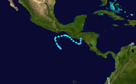
Based on satellite imagery, it is estimated the system developed into Tropical Depression One-E early on June 1, about 345 miles (555 km) south of the Gulf of Tehuantepec.
[2] Turning southeastward, Tropical Storm Andres passed about 35 miles (56 km) off the coast of Guatemala, before it began weakening due to interaction with the Intertropical Convergence Zone.
Instead, the system remained disorganized, bringing rainfall to Cuba, Florida, and the Bahamas before it was absorbed by a weak trough in the Gulf of Mexico.
[2] Due to the threat of the storm, officials closed ports along the southern Mexican coastline, and also advised for small boats to excise caution.
[5] Two fishermen were left missing in Nicaragua,[2] and the storm damaged 91 houses and destroyed 82 more, leaving a total of 1,259 people homeless.
[2] In Florida, the system produced a daily record precipitation of 5.89 inches (15.0 cm) at the Miami International Airport; the rainfall led to street flooding, accidents, and housing damage.
Tropical storm (39–73 mph, 63–118 km/h)
Category 1 (74–95 mph, 119–153 km/h)
Category 2 (96–110 mph, 154–177 km/h)
Category 3 (111–129 mph, 178–208 km/h)
Category 4 (130–156 mph, 209–251 km/h)
Category 5 (≥157 mph, ≥252 km/h)
Unknown
