U.S. Route 190
The western terminus is at a point where US 190 intersects with I-10, a few miles east of Bakersfield and 20 mi (32 km) west of the town of Iraan, in the middle of Pecos County.
Splitting from US 183 and continuing east, US 190 runs through Kempner and into the extreme southern corner of Coryell County and Copperas Cove, which is located on the southwestern edge of Fort Cavazos.
In Hearne, US 190 splits with US 79 and merges to run concurrently with SH 6 south, entering Brazos County, through Benchley, and into Bryan, that is considered the heart of the Brazos Valley (Southeast Central Texas), and is part of the Bryan-College Station metropolitan area.
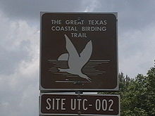
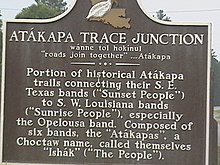
[3] Junction is where Louisiana Highway 111 (LA 111) and US 190 intersect and is the site of a roadside marker and the joining of two Indian trails.
From Junction, US 190 heads east to DeRidder, where it runs concurrently with US 171 south and passes several sites on the National Register of Historic Places, such as the Beauregard Parish Jail, Beauregard Parish Courthouse, and the DeRidder Commercial Historic District.
US 190 crosses the northern reach of the Atchafalaya Basin near the Morganza Spillway en route to Baton Rouge.
From Baton Rouge, US 190 passes, in places divided, through Denham Springs, Albany, Hammond, Robert, Goodbee, Covington,[a] Mandeville, before reaching the eastern terminus at Slidell.
The stretch between I-12 south of Covington and the intersection with LA 22 at Mandeville is multilane divided with controlled access, serving as the primary connector between I-12 and the north end of the Lake Pontchartrain Causeway.
[4][5] In the original 1926 plan, US 190 served the purpose of modern-day I-12 as the road around the north side of Lake Pontchartrain to avoid New Orleans.
[7][8] In 1935, the route was extended west across the Mississippi River, ending in the western Texas town of Brady at an intersection with US 87.
[7] US 190 was assigned to an additional 150 miles (240 km) across the sparsely populated areas of western Texas south of San Angelo in June 1977, taking effect January 1, 1978.
West of Baton Rouge, the current alignment generally follows the same route since its extension into Texas in 1935.
The $77.8 million project will improve driving safety along 7.3 miles of US 190 in central Texas, as new hardened medians will separate each side of traffic.
After delays due to the construction of what would become I-14 to the east of Copperas Cove,[17] the $46.5 million bypass opened on January 29, 2015, and the original alignment became Business US 190.
[18] Business US 190's western terminus is located at a signaled intersection with US 190 and Farm to Market Road 2657 (FM 2657).
Continuing eastward, the road intersects northbound FM 1113 and begins to enter the commercial district of Copperas Cove.
The road continues due east past the town's center until it merges with I-14, US 190, and State Highway 9 (SH 9).
This interchange is located within the boundaries of Fort Cavazos; the only access to the army base directly from US 190 Business is via Hood Road.
[15] As US 190 has come to be a major thoroughfare through central Texas, traffic could not handle the two lane road in the primarily residential area.
Entering the main residential part of the small town, the eastern terminus of FM 436 intersects Business US 190.
Moving north, the business route passes one block to the left of the Louisiana State Capitol and along the Mississippi River before merging onto N. 3rd Street and entering an industrial area.
[27] Although US 61/190 Business has been signed as such since 1960, it did not formally get approval from the American Association of State Highway Officials (AASHO) until 1968.
The business route continues eastbound into downtown Covington until it reaches Louisiana Highway 21 (LA 21).
[26] The road begins at the intersection of US 11 (Front Street) and Fremaux Avenue in the 'Olde Towne' neighborhood of Slidell.
After increased traffic on Gause Road and motorist confusion accessing US 190, the state of Louisiana petitioned AASHO to re-route the highway and create a new business route.
[31] Following Hurricane Katrina in 2005, the weigh station on I-10 near the US 190 Business overpass was permanently closed and razed.
In 2006, the Louisiana Department of Transportation and Development (LaDOTD) began construction on a new interchange at US 190 Business at the request of the St. Tammany Parish government and the City of Slidell.
Extensive traffic backups at the US 190 (Gause Boulevard) interchange and the planning of a new retail center prompted this to be one of many projects to revitalize the area following Hurricane Katrina.