U.S. Route 220 in Pennsylvania
In the state of Pennsylvania, the route runs 248 miles (399 km) from the Maryland border in Cumberland Valley Township, Bedford County northeast to an interchange with I-86/NY 17 in South Waverly, Bradford County a short distance south of the New York border.
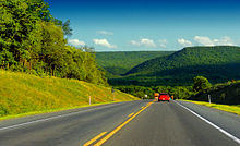
From the state line, the route heads northeast as a two-lane undivided road as it passes through a narrow agricultural valley surrounded by forested mountains.
A short distance later, the route comes to a cloverleaf interchange with US 30, which bypasses downtown Bedford to the north as a freeway.
The highway continues through a mix of farms and forests, with a diamond interchange at Sarah Furnace Road that provides access to Blue Knob State Park.
The highway bypasses Newry to the east prior to heading into more developed surroundings as it enters the Hollidaysburg area.
The road continues between development to the west and forested mountains to the east as it heads away from Altoona and reaches an interchange with the northern terminus of PA 764.
[1][2] I-99/US 220 continues northeast between a mountain to the east in an agricultural valley to the west, coming to an interchange with the southern terminus of PA 865 near Bellwood.
Past Tyrone, I-99/US 220 passes through forested areas and reaches a diamond interchange that serves PA 350 and the northern terminus of US 220 Bus.
From here, the freeway continues into Centre County and runs through rural areas before turning north to bypass Port Matilda to the west.
Immediately after this interchange, a southbound exit and northbound entrance serves Valley Vista Drive and provides access to US 322 Bus.
The freeway continues east into more developed areas with some woods and comes to a diamond interchange at Waddle Road that serves Toftrees.
An interchange serves Shiloh Road before the highway comes to the PA 150 exit near State Correctional Institution – Rockview.
The highway turns northeast and crosses Bald Eagle Creek prior to a diamond interchange with the eastern terminus of PA 120 to the south of Lock Haven.
US 220 continues east and crosses Bald Eagle Creek again before leaving the Lock Haven area and heading into rural surroundings.
The freeway passes through farmland and crosses the West Branch Susquehanna River before it comes to an interchange with the northern terminus of PA 150 near Avis.
The US 220 freeway bypasses Avis to the southeast and continues to the PA 44 exit, at which point that route joins US 220.
[1][2] The freeway crosses Pine Creek into Lycoming County and heads to the north of Jersey Shore.
The freeway ends prior to an at-grade intersection with the southern terminus of PA 287, at which point US 220 continues east as a four-lane divided surface road.
The freeway passes over Lycoming Creek immediately before an interchange with US 15, which currently serves as the southern terminus of I-99.
I-180/US 220 continues northeast through more developed areas, with a southbound exit and northbound entrance at Basin Street.
The freeway heads into a mix of farmland and woodland, reaching an interchange that serves the Lycoming Mall.
Past Picture Rocks, the road winds northeast along the banks of Muncy Creek through forested areas.
The road passes through more rural areas before PA 87 joins in from the west prior to reaching Dushore.
Past this, US 220 continues north as a two-lane undivided road through a mix of farmland and woodland along the west bank of the Susquehanna River, passing through Ulster and Milan.
US 220 crosses the Chemung River and comes to a diamond interchange at West Pine Street that serves Athens.
The highway continues between the river to the west and developed areas to the east before it reaches an interchange at Mile Lane Road that serves Sayre and South Waverly.
The route enters South Waverly and comes to its northern terminus at an interchange with I-86/NY 17, which is maintained by the state of New York despite being in Pennsylvania.
It picked up a concurrency with US 22 at Duncansville headed east to Hollidaysburg, then followed modern-day PA 36 north to a junction with Plank Road, and then followed US 220 BUS through Altoona.
It then passed through the Tuckahoe Valley northeasterly, paralleling the modern-day freeway to the northwest and servicing Tyrone directly.
In the late 1960s the federal government planned a dam in the Bald Eagle Valley, which would flood most of the original alignment through Howard.