U.S. Route 27 in Florida
It was named after long-time Florida statesperson Claude Pepper, who served in both the U.S. Senate and House of Representatives.
The stretch running from Miami to South Bay was originally designated the Thomas E. Will Memorial Highway by the Florida Legislature in 1937 when that portion was known as State Road 26 (SR 26).
[2] Thomas E. Will, the founder of Okeelanta, had worked for almost 20 years to get the state to build a road from Miami to the area south of Lake Okeechobee.
It then proceeds northwest for five miles (8.0 km) as South Okeechobee Road, parallel to the Miami Canal, forming the southwest boundary of the city of Hialeah.
After another four miles (6.4 km), the highway curves to the north and, after passing the northern terminus of SR 997 (Krome Avenue), crosses into Broward County.
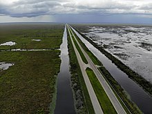
In Broward County, the highway passes protected wetlands and heavy-duty powerlines on the west and the outer reaches of the suburban communities of Pembroke Pines and Weston on the east where it curves to the northwest.
The highway skirts the southwestern shore of Lake Okeechobee and then heads west through Lake Harbor and then Clewiston, before making a sharp turn to the north toward Moore Haven, where it crosses the Mamie Langdale Memorial Bridge over the Caloosahatchee Canal and makes another sharp turn to the west.
Shortly after this, US 27/US 98 runs through a commercial strip area before curving to the west at a Y intersection along the south shore of Lake Jackson in Sebring, where SR 17 begins.
North of this point, US 27 becomes a six-lane highway and remains that way until reaching SR 540 in Waverly, where the road narrows down to four lanes again.
After passing the Florida Citrus Tower and Presidents Hall of Fame, the road enters Minneola along the east side of Lake Minneola, where it crosses a bridge over South Lake Trail, intersects such roads as CR Old 50, as well as CR 561, the latter of which it shares a brief concurrency.
Because of the frequent use of street-legal golf cars in the community, bridges and tunnels for these carts can be found throughout the road.
Near the right-of-way for the formerly proposed Cross Florida Barge Canal, the median for the road widens but narrows back down to normal again.
To the west of this intersection is the Santos Trailhead of the Marjorie Harris Carr Cross Florida Greenway.
The US 27/US 41 concurrency is one of the few segments that are only two lanes wide, and it begins to lean to the northwest until briefly shifting straight north before approaching Archer, where it intersects CR 346, then a former Florida Central and Peninsular Railroad right-of-way, and finally SR 24.
US 27 heads west along unsigned SR 20, which is named First Avenue until it crosses the Santa Fe River and enters Columbia County.
From here, it continues to run northwest but briefly turns straight west after entering Fort White just before intersecting SR 47.
[7] Both US 27 and the trail run through Hildreth, the home of Ichetucknee Springs State Park, and then encounters the east end of a concurrency with US 129 (SR 49) which is also the southern terminus of CR 49.
A slight curve to the southwest is where both routes officially enter Branford where US 129 turns north onto unsigned SR 249.
The road runs through the rural community of Alton, then slows down as it enters Mayo where it intersects SR 51, the northwest corner of which contains the historic Lafayette County Courthouse.
Swampland continues to surround US 27 until it comes close to Perry, where a small truck weigh station can be found along the westbound shoulder.
The parkway has a short expressway section just east of the capitol, then is a busy four-lane surface boulevard with service roads for the next few miles, passing Governor's Square, the Centre of Tallahassee, and many state office buildings.
US 27 runs west along this stretch of road however, and the Apalachee Parkway ends at SR 61 (Monroe Street) in front of the Florida State Capitol building.
SR 63 approaches its only suffixed auxiliary route in the form of CR 63A before encountering a partial cloverleaf interchange with I-10 (exit 199).
The road runs along the west side of Tallahassee Commercial Airport and makes a reverse curve as it approaches a bridge over the Ochlockonee River, where it crosses the Leon–Gadsden county line and continues to move northwest.
Further north, CR 159 secretly joins US 27/SR 63 in a triple concurrency, and all three routes approach a CSX Transportation railroad line until they curve northeast before entering the town of Havana.
Shortly after its second landfall, Hurricane Irma's eye traveled roughly along the entire course of US 27 in Florida north of Lake Placid.