U.S. Route 27
[1] From Miami, it goes up the center of Florida, then west to Tallahassee, Florida, and north through such cities and towns as Columbus, Georgia; Rome, Georgia; Chattanooga, Tennessee; Lexington, Kentucky; Cincinnati, Ohio; Oxford, Ohio; Richmond, Indiana; and Fort Wayne, Indiana.
The stretch running from Miami to South Bay was originally designated the Thomas E. Will Memorial Highway by the Florida Legislature in 1937 when that portion was known as State Road 26 (SR 26).
[7] Will, the founder of Okeelanta, had been instrumental in getting the state to build the road from Miami to the area south of Lake Okeechobee.
US 27 begins as North 36th Street in Midtown Miami, heading west from US 1 for 4.4 miles (7.1 km) before turning northwest to pass under the western terminus of SR 112 (Airport Expressway).
It then proceeds northwest for five miles (8.0 km) as South Okeechobee Road, parallel to the Miami Canal, forming the southwest boundary of the city of Hialeah.
After another four miles (6.4 km), the highway curves to the north and, after passing the northern terminus of SR 997 (Krome Avenue), crosses into Broward County.
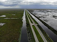
In Broward County, the highway passes protected wetlands and heavy-duty powerlines on the west and the outer reaches of the suburban communities of Pembroke Pines and Weston on the east.
US 27 then reaches an interchange with I-75 and Alligator Alley before curving to the northwest toward South Bay and Lake Okeechobee.
The highway skirts the southwestern shore of Lake Okeechobee and then heads west at Clewiston, before making a sharp turn to the north toward Moore Haven.
US 27 heads west along the unsigned SR 20 toward Perry and joins US 19 until US 19 breaks away in Capps, but not before resuming a westward direction.
Constructed in 1957, the Apalachee Parkway starts at SR 61 (Monroe Street) in front of the Florida State Capitol building.
It has a short expressway section just east of the capitol, then is a busy four-lane surface boulevard with service roads for the next few miles, passing the Governor's Square mall and many state office buildings.
Throughout its approximately 80-mile (130 km) stretch between Chattanooga and Harriman, US 27 traverses a valley between the Tennessee River to the east and the Cumberland Plateau to the west.
At Elgin, it intersects SR 52, which connects the area with the historic village of Rugby and Fentress County to the west.
In Oneida, US 27 intersects SR 297, which continues westward into the Big South Fork National River and Recreation Area.
The first major town it goes through is Somerset, followed by Stanford, Lancaster, Nicholasville, and Lexington, where it begins a concurrency with US 68 that continues to Paris.
US 27 continues north from there through Cynthiana, Falmouth, Alexandria, Cold Spring, Highland Heights, Fort Thomas, Southgate, and Newport before crossing into Ohio at Cincinnati via the Taylor–Southgate Bridge.
From its junction with I-471 in Highland Heights through most of Campbell County, it is a four-lane highway, as it is with the US 68 concurrency and south from Lexington to Kentucky Route 34.
In 1937, the route was extended concurrently with US 23 to Mackinaw City, where it ended at the Michigan State Auto Ferry Dock along with US 23 and US 31.