U.S. Route 491
[2] This Satanic connotation, combined with a high fatality rate along the New Mexico portion, convinced some people the highway was cursed.
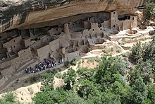
Other features along the route include Mesa Verde National Park and Dove Creek, Colorado, the self-proclaimed pinto-bean capital of the world.
[10] The Navajo tribal capital at Window Rock, Arizona, is just west of the highway corridor, accessed by State Road 264 (NM 264).
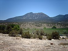
The largest city served by US 491 is Shiprock, which takes its name from one of several extinct volcano cores in the area.
After passing Shiprock, the route continues north to the Colorado state line.
[14] The highway exits tribal lands near Cortez and Mesa Verde National Park.
[6] Before the Mexican–American War, when this area was ceded to the United States, the main trade route through this part of Mexico was the Old Spanish Trail.
The modern US 491 roughly correlates with the main route of the Old Spanish Trail between Cortez, Colorado and its northern terminus.
[25] This nickname and association made some visitors uncomfortable,[26] as well as making the signs targets for theft.
[28] One unnamed highway patrol officer was quoted in USA Today as stating a drunk-driving suspect told him, "Triple 6 is evil.
[28] Skeptics further state the high fatality rate in New Mexico can be explained by an inadequate design for the traffic loads at the time.
[32] On December 4, 1938, the southern terminus of the route was extended from Gallup across the Arizona state line to US 80 in Douglas, near the Mexican border.
[35] This portion is noted for mountainous terrain, with hairpin turns and steep grades, that reaches an altitude of over 9,000 feet (2,700 m).
As part of this change, US 160 was rerouted west of Cortez to serve the Four Corners Monument and enter Arizona instead of Utah.
[37] In 1985, the Utah Department of Transportation petitioned to extend US 666 northwest to Richfield, but the proposal was rejected.
One of the reasons cited for rejecting the proposal was that portions of SR 24 were not built to standards desired for additions to the U.S. Highway System.
[2] At the news that the motion had passed, a New Mexico spokesperson stated, "The devil's out of here, and we say goodbye and good riddance.
"[28] Referring to the motion passing with a different number from what New Mexico requested, another spokesperson responded, "As long as it's not 666 and it's nothing satanic, that's OK."[2] US 666 officially ceased to exist on May 31, 2003, although temporary "New 491 – Old 666" signs were posted after the change to aid travelers using old maps.
[39] Officials in Utah reported that five entire sign assemblies had been cut down with a chainsaw and stolen, while New Mexico officials reported that even signs welded to metal posts, as a theft deterrent, had been stolen.
Officials speculated from one scene that someone had intentionally crashed a car into the sign post to break the welds.
[25] At the dedication George Blue Horse, a Navajo medicine man, performed a ceremony to remove the curse from the highway.
"[28] Newspapers and television stations interviewed people along the route about their opinions on the changing of the highway's number.
One Monticello resident stated, "We'll really miss all the potheads stopping and taking pictures of the Route 666 sign."
[25] Since the renumbering in 2003, portions of US 491 in New Mexico have been upgraded to a four-lane divided highway, with grade separations at the busiest interchanges.
[3] Construction on the final phase was originally scheduled to begin January 2008,[10] however the state applied for American Recovery and Reinvestment Act funds to finish the project and completion was delayed until 2012.