U.S. Route 80
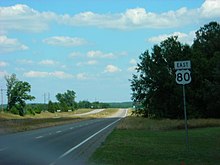
With Spur 557, it serves as the shortest freeway route from the central and northern portions of Dallas to I-20, heading east towards Shreveport, Louisiana.
From its origin at I-30 in eastern Dallas, through its interchange with the I-635 "LBJ" Loop, to its junction with I-20 southwest of Terrell, US 80/Spur 557 is a full Interstate-grade, limited-access freeway.
The highway passes over I-220 without an interchange and continues east to an intersection with Jefferson Paige Road where it expands to four undivided lanes and enters the main part of the urbanized area.
Through Bossier Parish, US 79/US 80 comprises a major urban and suburban arterial (East Texas Street) carrying a minimum of four lanes.
US 80 crosses Louisiana Highway 143 (LA 143) and enters West Monroe on Cypress Street, where it continues south into the business district and widens to a four-lane urban arterial.
At junction LA 34 (Bridge Street), US 80 makes a left turn, angling northeast, and crosses the Ouachita River, entering the city of Monroe.
Louisville Avenue rapidly becomes a heavily commercialized urban arterial and remains so as it passes through the city, eventually curving southwestward and meeting the intersection with Desiard Street.
In Mississippi, US 80 is referred to as "Highway 80" and exists primarily as a two-lane road except in the Jackson area, where it expands to four lanes.
After Brandon, US 80 runs parallel to I-20 for the next 100 miles (160 km) through the towns of Pelahatchie, Morton, Forest, Lake, Newton, Hickory, and Chunky.
Past Columbus, the road meanders through rural Georgia for roughly 50 miles (80 km) en route to Macon, where it crosses I-75 and I-16.
US 80 passes through downtown Macon via Eisenhower Parkway and parallels the northern boundary of Ocmulgee National Monument just east of the city.
California politicians Stanley Hufflund and Ed Fletcher convinced the association in an August 1918 meeting to choose San Diego over Los Angeles.
Fletcher was responsible for a grassroots campaign years earlier that resulted in the construction of the Plank Road across the Algodones Dunes in 1915.
In April 1925, the Secretary of Agriculture established the Joint Board on Interstate Highways under the United States Bureau of Public Roads.
During his time with the association, Fletcher lobbied the federal government to pay for improvements to the highway and actively promoted US 80 to motorists.
According to the United States Department of Agriculture Bureau of Public Roads, only 798 miles (1,284 km) were considered "improved" roadway in 1931, being paved with brick, concrete or macadam.
[6] In 1947, the U.S. Highway 80 Association (not to be confused with Fletcher's earlier organization) was founded to promote business and tourism along US 80 from Savannah to San Diego.
[22] Lee Harvey Oswald was captured at the Texas Theatre on Jefferson Street in Oak Cliff, which at the time was a business spur of US 80.
Prior to the successful march, the Edmund Pettus Bridge on US 80 in Selma was the site of the infamous Bloody Sunday event, where marchers were beaten and wounded by local law enforcement and armed vigilantes.
In downtown Dallas, President John F. Kennedy was shot in Dealey Plaza just blocks from Commerce Street, which was part of US 80 and Business US 80.
In Descanso Junction, the pre-interstate route follows Wildwood Glen Lane from a dead end on the north side of I-8 to CA 79.
[16] From Buckeye Road, US 80 travelled north on 17th Avenue, then east on Van Buren Street through the Phoenix metro area.
AZ 80 takes its number from the former U.S. Highway and makes up the majority of the former route through Cochise County through Tombstone, Bisbee and Douglas to NM 80 at the New Mexico state line.
[12] In Tucson there are over 281 extant historic motels and structures along the original US 80 alignment, especially on the Miracle Mile and Benson Highway segments.
[4] US 80 entered New Mexico on present day NM 80 passing through Rodeo before heading north to join the route of I-10 at Road Forks.
[55] Approaching downtown Dallas, the older route of US 80 used Fort Worth Avenue and Commerce Street, designated Loop 260 and Bus.
[57]) The later US 80 continued east on Davis Street, turning north at Zang Boulevard (Loop 354 until 1991), shifting to a route via SH 180 to I-35E after 1961.
[64][65] In both cases, new alignments carried traffic eastward from the bridges, bypassing the original routes through Bossier City and downtown Monroe.
Minor relocation of the highway has also resulted from overpasses replacing several at-grade railroad crossings, as US 80 parallels what is now the Kansas City Southern Railway throughout the state.
The Alabama National Guard, Selma and Dallas County law enforcement as well as armed non-law enforcement individuals brutally beat and trampled Civil Rights protesters with police batons, horses and barbed wire bats, bringing a pre-mature end to an attempted march to Montgomery.