Uinta Basin
They contain the highest point in Utah, Kings Peak, with a summit 13,528 feet (4,123 metres) above sea level.
1822–1840 French Canadian trappers Étienne Provost, François le Clerc, and Antoine Robidoux entered the Uinta Basin by way of the Old Spanish Trail and made their fortunes by trapping the many beaver and trading with the Uintah tribe.
The local economy, once based on agriculture and mining, has diversified, and energy extraction and tourism are now major industries as well.
The basin is 5,000 to 10,000 feet (1,500 to 3,000 m) above sea level and corresponding to this depression is a broad east–west strip of higher plateau that rises sharply above the denuded country to the south.
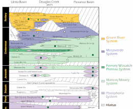
[4][5] During the Laramide Orogeny along the Wasatch Mountains, the north–south trending coast during the Late Cretaceous was receding eastward, at the same time the area where the basin is located was subsiding, creating a lacustrine environment.
A clastic wedge consisting of the North Horn, Colton, and Wasatch was deposited northwards.
These sediments interfingered with organic-rich lacustrine clays and carbonate muds of the Green River and Flagstaff facies.
Later, deposits originated from the Uinta Mountains from the north, forming a southward-thinning clastic wedge.
A carbonate sediment consisting of an organic-rich oil shale was deposited from the middle Eocene into the Oligocene.