Ujung Kulon National Park
The park fully encompasses the Ujung Kulon peninsula, along with surrounding islands and the Gunung Honje mountain range.
[6] Most of the park landmass lies on the mainland, specifically the Ujung Kulon Peninsula, with the highest elevation of 480 m (1,570 ft) atMt.
[7] The Ujung Kulon area was first introduced to the Western world by Dutch-German botanist, Franz W. Junghuhn in 1846, during one of his expeditions.
[9] Following the Krakatoa eruption and the ensuing tsunami, which was reported to be 15 meters high, many of the peninsula's settlements were destroyed and never completely rebuilt.
[9][10] The eruption also obliterated much of the local flora and fauna, leaving an average 30 cm (12 in) layer of volcanic ash across the area.
[citation needed] Despite this, the area rapidly recovered, enabling it to serve as a repository for a large portion of Java's flora and fauna as well as the majority of the island's lowland forest.
[9] It is Indonesia's first proposed national park coincidentally designated as a UNESCO World Heritage Site in 1991 during its establishment for containing the largest remaining lowland rainforest in Java.
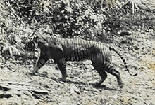
[13] So far, 175 species have been observed within the park, with 57 of them being protected, This includes mangroves (e.g. Sonneratia alba, Excoecaria agallocha, Rhizophora apiculata, Aegiceras corniculatum), coastal plants (e.g. Nypa fruticans, Calophyllum inophyllum, Terminalia catappa, Hibiscus tiliaceus, etc.
[14] The park possesses three protected rare flora, namely Heritiera percoriacea, Vatica bantamensis, and Intsia bijuga.
This species of palm has been noted to grow rapidly while consuming much area, starving the undergrowth of sunlight, reducing the rhino's required food supply.