Submarine canyon
Turbidity currents are flows of dense, sediment laden waters that are supplied by rivers, or generated on the seabed by storms, submarine landslides, earthquakes, and other soil disturbances.
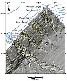
While at first glance the erosion patterns of submarine canyons may appear to mimic those of river-canyons on land, several markedly different processes have been found to take place at the soil/water interface.
Canyons are steeper, shorter, more dendritic and more closely spaced on active than on passive continental margins.
However, while many (but not all) canyons are found offshore from major rivers, subaerial river erosion cannot have been active to the water depths as great as 3,000 meters (9,800 ft) where canyons have been mapped, as it is well established (by many lines of evidence) that sea levels did not fall to those depths.
There is a spectrum of turbidity- or density-current types ranging from "muddy water" to massive mudflow, and evidence of both these end members can be observed in deposits associated with the deeper parts of submarine canyons and channels, such as lobate deposits (mudflow) and levees along channels.
However, if a primary mechanism must be selected, the downslope lineal morphology of canyons and channels and the transportation of excavated or loose materials of the continental slope over extensive distances require that various kinds of turbidity or density currents act as major participants.
The sea which is normally repleted by contact and inflow from the ocean is now no longer replenished and hence dries up over a period of time, which can be very short if the local climate is arid.