Uruguay River
It flows from north to south and forms parts of the boundaries of Brazil, Argentina and Uruguay, separating some of the Argentine provinces of La Mesopotamia from the other two countries.
It passes between the states of Santa Catarina and Rio Grande do Sul in Brazil; forms the eastern border of the provinces of Misiones, Corrientes and Entre Ríos in Argentina; and makes up the western borders of the departments of Artigas, Salto, Paysandú, Río Negro, Soriano and Colonia in Uruguay.
The name of the river tends to comes from the Spanish settlers' interpretation of the Guaraní language word the inhabitants of the region used to designate it.
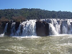
[9][11] The 17,491 ha (43,220 acres) Turvo State Park, created in 1947, protects the Brazilian side of the falls.
Two European companies, ENCE and Botnia, proposed building cellulose processing plants at Fray Bentos, Uruguay, opposite Gualeguaychú, Argentina.
[19] Starting in April 2005, residents of Gualeguaychú, as well as many others, protested, claiming that the plants would pollute the river shared by the two countries.
Early in 2006, the conflict escalated into a diplomatic crisis,[citation needed] compelling one of the companies move the project 250 kilometres (160 mi) south.