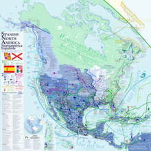
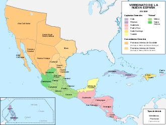
New Spain
New Spain developed strong regional divisions based on local climate, topography, distance from the capital and the Gulf Coast port of Veracruz, size and complexity of indigenous populations, and the presence or absence of mineral resources.
At the local level there were over two hundred districts, in both indigenous and Spanish areas, which were headed by either a corregidor (also known as an alcalde mayor) or a cabildo (town council), both of which had judicial and administrative powers.
In the late 18th century the Bourbon dynasty began phasing out the corregidores and introduced intendants, whose broad fiscal powers cut into the authority of the viceroys, governors and cabildos.
Reforms included the improvement of public participation in communal affairs, distribution of undeveloped lands to the indigenous and Spaniards, ending the corrupt practices of local crown officials, encouraging trade and mining, and establishing a system of territorial division similar to the model created by the government of France, already adopted in Spain.
During the era of the conquest, in order to pay off the debts incurred by the conquistadors and their companies, the new Spanish governors awarded their men grants of native tribute and labor, known as encomiendas.
The fast red dye cochineal was an important export in areas such as central Mexico and Oaxaca in terms of revenues to the crown and stimulation of the internal market of New Spain.
So then, the ships that set sail from Veracruz were generally loaded with merchandise from the East Indies originating from the commercial centers of the Philippines, plus the precious metals and natural resources of Mexico, Central America, and the Caribbean.
However, these resources did not translate into development for the Metropolis (mother country) due to Spanish Roman Catholic Monarchy's frequent preoccupation with European wars (enormous amounts of this wealth were spent hiring mercenaries to fight the Protestant Reformation), as well as the incessant decrease in overseas transportation caused by assaults from companies of British buccaneers, Dutch corsairs and pirates of various origin.
[30] Even in the relatively richly endowed region of Mexico, the difficulty of transit of people and goods in the absence of rivers and level terrain remained a major challenge to the economy of New Spain.
[33] Even where infrastructure was improved, transit on the Veracruz-Puebla main road had other obstacles, with wolves attacking mule trains, killing animals, and rendering some sacks of foodstuffs unsellable because they were smeared with blood.
[39] Some Spaniards lived in semitropical Córdoba, which was founded as a villa in 1618, to serve as a Spanish base against runaway slave (cimarrón) predations on mule trains traveling the route from the port to the capital.
[40] European diseases immediately affected the multiethnic Indian populations in the Veracruz area and for that reason Spaniards imported black slaves as either an alternative to indigenous labor or its complete replacement in the event of a repetition of the Caribbean die-off.
Its location on the main route between the viceregal capital and the port of Veracruz, in a fertile basin with a dense indigenous population, largely not held in encomienda, made Puebla a destination for later arriving Spaniards.
[65] Although Indians migrated willingly to the region, they did so in such small numbers that labor shortages prompted Spanish hacendados to provide incentives to attract workers, especially in the initial boom period of the early seventeenth century.
[66][67] For example, in 1775 the Spanish administrator of a San Luis Potosí estate "had to scour both Mexico City and the northern towns to find enough blue French linen to satisfy the resident employees".
[78] The Presidios (forts), pueblos (civilian towns) and the misiones (missions) were the three major agencies employed by the Spanish crown to extend its borders and consolidate its colonial holdings in these territories.
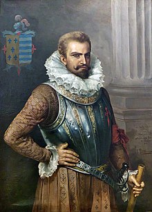
In 1595, Don Juan de Oñate, son of one of the key figures in the silver remining region of Zacatecas, received official permission from the viceroy to explore and conquer New Mexico.
[79] Oñate pioneered 'The Royal Road of the Interior Land' or El Camino Real de Tierra Adentro between Mexico City and the Tewa village of Ohkay Owingeh, or San Juan Pueblo.
He also founded the Spanish settlement of San Gabriel de Yungue-Ouinge on the Rio Grande near the Native American Pueblo, located just north of the modern city of Española, New Mexico.
[80] Oñate eventually learned that New Mexico, while it had a settled indigenous population, had little arable land, no silver mines, and possessed few other resources to exploit that would merit large scale colonization.
The Spanish colonies there, having far fewer known natural resources and less cultural development than Mexico or Peru, were to combine establishing posts to defend the territory with a perceived responsibility to convert the indigenous people to Catholicism.
[89] With dense indigenous Maya populations, Yucatán's encomienda system was established early and persisted far longer than in central Mexico, since fewer Spaniards migrated to the region than in the center.
In the economic sphere, unlike many other regions and ethnic groups in Mesoamerica, the Yucatec Maya did not have a pre-conquest network of regular markets to exchange different types of food and craft goods.
[97] In the seventeenth century, patterns shifted in Yucatán and Tabasco, as the English took territory the Spanish claimed but did not control, especially what became British Honduras (now Belize) and in Laguna de Términos (Isla del Carmen) where they cut logwood.
[102] The most extensive study of Oaxaca's eighteenth-century economy deals with the nexus between the local crown officials (alcaldes mayores), merchant investors (aviadores), the repartimiento (forced labor), and indigenous products, particularly cochineal.
cash loaned by local crown officials (the alcalde mayor and his teniente), usually to individual Indians but sometimes to communities, in exchange for a fixed amount of a good (cochineal or cotton mantles) at a later date.
[111] The most detailed economic records for the region are of the Marquesado's ranching haciendas, which produced draft animals (horses, mules, burros, and oxen) and sheep and goats, for meat and wool.
Tallow for candles used in churches and residences and leather used in a variety of ways (saddles, other tack, boots, furniture, machinery) were significant items in the larger colonial economy, finding markets well beyond Tehuantepec.
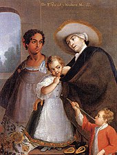
More than a century would pass before Mexico conducted a new census on which a person's race was listed, in 1921,[127] but even then, due to its huge inconsistencies with other official registers as well as its historic context, modern investigators have deemed it inaccurate.
Architects Pedro Martínez Vázquez and Lorenzo Rodriguez produced some visually frenetic architecture known as churrigueresque in the capital, Ocotlan, Puebla and some remote silver-mining towns.