Vikna Municipality
It was named after the three large islands which made up the municipality: Inner-Vikna, Mellom-Vikna, and Ytter-Vikna (Old Norse: Víkn).
The official blazon is "Azure, three salmon argent in annulo" (Norwegian: I blått tre sølv lakser som danner en sirkel).
The fish design has a tincture of argent which means it is commonly colored white, but if it is made out of metal, then silver is used.
The highest point in the municipality was the 172.9-metre (567 ft) tall mountain Vattafjellet on the island of Ytter-Vikna.
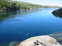
[1] The main village for the municipality was Rørvik, located on the eastern shore of Inner-Vikna, facing the mainland across the Nærøysundet strait.
On 21 October 1962, the coastal steamer (Hurtigruten) Sanct Svithun run aground on Nordøyan as a result of navigational error.
The municipal council (Kommunestyre) of Vikna was made up of 23 representatives that are elected to four year terms.
The Vikna Wind Farm is located on Mellom-Vikna, just west of Garstad, and it produces power for much of the municipality.
Hurtigruten boats stop frequently at Rørvik and Norwegian County Road 770 via the Nærøysund Bridge connects Vikna to the mainland and European route E6.
Vikna and neighbouring Nærøy Municipality formed a common work area with nearly 10,000 inhabitants.