Neighborhoods in Pasadena, California
Most of the area is served by McKinley School and Blair High School Old Pasadena is the historic core of Downtown Pasadena; it has a multitude of fine shops and restaurants (Italian and Japanese restaurants are especially numerous here).
There are two parks, the historic Del Mar Station and Castle Green, and the headquarters of Parsons.
It also houses several municipal government offices, though notably not the Department of Public Works, which is in Banbury Oaks.
Monk Hill is the westernmost part of Downtown Pasadena and is home to the Norton Simon Museum and Ambassador Auditorium.
[1] The neighborhood's east end has the Ice House comedy club and Boston Court Pasadena, an arthouse.
The USC Pacific Asia Museum, which started in 1971, is located on North Los Robles Avenue.
[2] Northwest Pasadena is bordered on the north and west by the city limits, on the south by the 210 and 134 Freeways, and the east by Los Robles and El Molino Avenues.
Residents of Northwest Pasadena generally attend John Muir High School.
The Banbury Oaks Neighborhood Association[5] sets Banbury Oaks' boundaries at Sunset Ave. between Claremont St. and Mountain St. including 1/2 block of Claremont St. between Glen Ave. & Sunset Ave.[5] The neighborhood is bisected by the 210 freeway.
Garfield Heights is bordered by Washington Boulevard to the north, Mountain Street to the south, North Marengo Avenue to the west, and Los Robles Avenue to the east.The original tract's name was registered with the city of Pasadena in 1904.
Lincoln-Villa's central plaza covers a couple of city blocks around the intersection of Fair Oaks Avenue and Orange Grove Boulevard, in addition to commercial developments on Fair Oaks, Villa Street, and Peoria Street.
Lincoln-Villa has some of Pasadena's heaviest street traffic, as a result of the aforementioned freeway interchange and the neighborhood's position between Downtown and the Rose Bowl.
It surrounds the recreation center with the same name, located at Villa Street and Euclid Avenue.
At the district's southern edge is the iconic brick clock tower at St. Andrew's Church.
Lake Avenue and Washington Boulevard have some commercial development, but for the most part Lexington Heights is a residential neighborhood.
It is notable for having been renamed several times, having been known as part of Orange Heights until the 1950s; in the 1980s it was renamed CLEM (short for Claremont, Lake, El Molino, and Mountain; the streets then encompassing the official area), then Heather Heights until the late 1990s when it was given its current name.
The land that became Washington Square was a large open field that eventually got replaced by a patchwork of small olive and orange groves.
Gang violence and drug manufacturing became rampant, and historic buildings were demolished in favor of low-rent apartments and cheap shopping centers.
The Great Recession followed a 20-year-long wave of gentrification and the neighborhood quickly fell into disrepair, struggling with safety and vacancy.
To combat this issue, In 2003 residents joined together to form the Washington Square Neighborhood Association successfully reducing crime and establishing Washington Square as a historic Pasadena landmark district encompassing approximately 250 homes built mainly between 1910 and 1940.
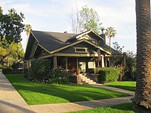
Architectural styles range from California Craftsman, Spanish Colonial, Tudor, English Cottage to Traditional.
All contributing properties are eligible for the Mills Act which gives homeowners a substantial real estate tax savings for maintaining their historic home.
Washington Square is served by Metro Local line 662; as well as Pasadena Transit routes 20, 31, 32 and 33.
Major streets are: Northeast Pasadena is the area north of the 210 freeway, between Hill Avenue and the Eaton Wash.
The Bridgen Ranch Neighborhood Association defines the borders of Bridgen Ranch as Galbreth Road on the north (including Westlyn Place and Eastlyn Place), Casa Grande Street on the south, North Allen Avenue on the west, and Martelo Avenue on the east.
East Washington Village has heavy commercial development throughout its entire length, and has undergone significant redevelopment in the last decade.
Burrito Express, on the corner of Washington Boulevard and Sierra Bonita Avenue, is located in the neighborhood.
Marine Corps Reserve Training Center, Blecksmith Hall, borders victory park to the South, East.
The Metro A Line has a station on Sierra Madre Villa Avenue and Foothill Boulevard, in this section of Pasadena.
The vast majority of commercial activity is centered on the PCC Campus, especially on Colorado Boulevard.