Washington Street (Boston)
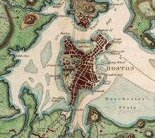
Until 1803 and the commencement of large-scale infilling of Boston Harbor and Back Bay, the town lay at the end of a peninsula less than a hundred feet wide at its narrowest point.
These fortifications were gradually improved over the years, and considerably expanded by the British as the movement for colonial independence moved from widespread discontent to frank military revolution.
This was done in honor of George Washington, who rode the Post Road into Boston during his tour of New England in October of that year.
[3] The name "Washington Street" was extended on July 6, 1824 to include the roads leading north to Dock Square.
For a period of time afterwards, Washington Street extended westward from Dudley Square to the border with Brookline.
[5] Part of this extension (from present-day Columbus Avenue to the Brookline border) was renamed Tremont Street on July 2, 1860.
[9] In 1802, Fisher Ames and a group of others requested that the Great and General Court lay out a new turnpike between the Norfolk County Courthouse and Pawtucket.
[12] It was the best and fastest highway in America at the time, allowing for mail to be delivered between Boston and Providence in under three hours.
The turnpike ran from Dudley Square to the border of Rhode Island and beyond to downtown Pawtucket.
The southern half of the turnpike, which had some steep grades and bypassed towns where travelers wanted to stop, saw little use and remained a dirt road until the construction of US 1.
From Marginal Road, south to Herald Street, the bridge over the Massachusetts Turnpike and the adjacent Amtrak/Massachusetts Bay Transit Authority (MBTA) commuter rail tracks, the road is also one-way northbound, with a southbound contra-flowing bus lane for the Silver-Line bus.
Washington Street currently has the following route numbers: When the first numbered highways in Massachusetts, the New England Interstate Highways, were assigned in 1922, NE 1 used Washington Street through North Attleborough center and from Norwood center to Arborway in Boston.
Soon after 1933, the new road (Boston-Providence Turnpike and Brook Farm Parkway) from Roslindale to Foxborough was finished, and it was around this time that the rest of the current alignment to Rhode Island was finished — using Washington Street from Foxborough to the state line, except through North Attleborough center.
On September 2, 1890, the line on Washington Street to Forest Hills began electric operation, again using Shawmut Avenue north of Dudley Square.
[17] A later, 1899 map, shows that tracks owned by the West Roxbury and Roslindale Street Railway continued southwest from Forest Hills via Dedham to Norwood.
Except for the older section through North Attleborough center, used by the Interstate Consolidated Street Railway, none of the rest had streetcar tracks, due to its avoidance of populated areas.