Transportation in Boston
The Massachusetts Bay Transportation Authority (MBTA) operates bus, subway, short-distance rail, and water ferry passenger services throughout the city and region.
For most of the 1990s and early 2000s, driving in Boston was disrupted by the Big Dig, the most expensive (roughly $14 billion) road project in the history of the US.
After more than 15 years of disruption, The Big Dig, along with other highway projects, provided less than 10 years of relief before congestion returned to the levels seen in "prerecession 2005, when the Big Dig was almost complete and marketed as the solution to gridlock for commuters ... analyses would conclude that the added capacity attracted more drivers, and pushed the traffic bottlenecks farther into the suburbs.
The complex and still-changing road network, with many one-way streets and time-based traffic restrictions, has led many Boston travelers to consider an up-to-date GPS navigation map system a necessity.
The Minuteman Bikeway (which runs through several suburbs northwest of Boston) and the Charles River bike paths are popular with recreational cyclists and tourists.
The Emerald Necklace system of parklands and parkways, pioneered by Frederick Law Olmsted and his sons, provides some more pleasant alternative routes for cyclists.
In addition, a small private company called Rubel BikeMaps has for many years published and distributed an extensive lineup of books and maps covering Boston, the state of Massachusetts, and nearby areas of New England.
[20] Prepared by the Association for Public Transportation (APT), this book contains extensive information useful to bicyclists and pedestrians alike, including coverage of intermodal travel and handicapped accessibility.
Although the general overview and travel tips are largely still relevant, this classic book has not been updated since 2003, and must be supplemented by current online information.
The MBTA was one of the earliest large transit agencies to embrace the Open Data philosophy, making route, scheduling, and real-time vehicle location information publicly available in the standard GTFS format.
[21] As a result, many third-party apps are available on a number of hardware platforms, allowing riders a wide range of choices in obtaining travel information.
In an effort to provide service intermediate in speed and capacity between subways and buses, the MBTA has begun projects using bus rapid transit (BRT) technology.
The MASCO M2 shuttle between Harvard Square and the LMA via Massachusetts Avenue is available for public use, though tickets or cash card must be purchased in advance.
In June 2014, the Cambridge-based startup Bridj began running "data driven" bus service in core neighborhoods.
[35] The MBTA operates several large park and ride facilities on its subway and commuter rail lines, close to major highways, providing access to downtown.
While most of these tend to fill up with commuters on weekday mornings, they provide a good place for visitors to leave their cars and see the city without parking hassles on evenings and weekends.
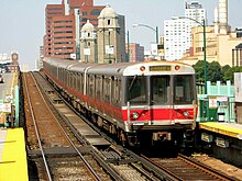
(The Red, Orange, Blue, and Green Lines have no physical rail interconnections with each other, though they are all operated by the MBTA and exchange passengers in shared stations.)
Additionally, the Green and Mattapan Lines are technically light-rail services, using LRVs and streetcars rather than typical multiple unit heavy railcar equipment.
Due to a sparsity of data collected by the existing system, real-time Green Line arrival predictions are not expected until tracking infrastructure upgrades are completed in 2015.
Although most such transfers can be achieved using the Orange Line between Back Bay and North Station, Amtrak recommends passengers with luggage to use a taxi.
PAR is a class II railroad that operates lines to the north and west of Boston, reaching destinations in New Hampshire, Maine and New York as well as Massachusetts.
[41][45] Only a few rail freight customers remain in or near Boston, including a chemical packager in Allston, and food distribution facilities and a scrap metal processor in Everett.
[46][47][48] In the face of community opposition and pressure from the state legislature, the company withdrew its proposal on July 2, days before the Lac-Mégantic derailment.
Land reclamation and conversion to other uses means that downtown area no longer handles commercial traffic, although the US Coast Guard maintains a major base there, and there is still considerable ferry and leisure usage.
Other major forms of cargo processed at the port include petroleum, liquefied natural gas (LNG), automobiles, cement, gypsum, and salt.
Other companies operate duck tours that use amphibious vehicles (mostly derived from World War II era DUKWs), and encompass both the city's streets and its waterways.
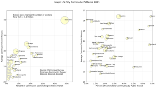
The average amount of time people spend commuting with public transit in Boston, for example to and from work, on a weekday is 83 min.
During the period starting in 2006 and ending in 2013, the Boston MSA had the greatest percentage decline of workers commuting by automobile (3.3 percent) among MSAs with more than a half-million residents.
Logan Airport is operated by the Massachusetts Port Authority (Massport) and has extensive domestic and international airline service.
Because of this and its location as the closest American port to Europe, Boston is an emergency destination for airliners that experience security or mechanical problems while en route to the US, although they may also be diverted to Halifax, Nova Scotia, or other Canadian airports.