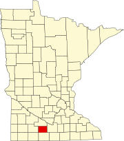
Watonwan County, Minnesota
Only two years later, by 1855, the western part of Blue Earth was then partitioned to create Brown County.
Five years later, on February 25, 1860, the southern part of Brown was partitioned to create the county of Watanwan, with the town of Madelia as the original designated county seat.
"[4] The word first appears in the modern written record on an 1843 map of the area so naming the river.
[5] The terrain of Watonwan County consists of low, rolling hills carved by drainages and dotted with lakes and ponds.
[7] The terrain slopes to the north and east, with its highest point near its southwest corner, at 1,293 ft (394 m) ASL.
[17] The top five reported ancestries (people were allowed to report up to two ancestries, thus the figures will generally add to more than 100%) were English (76.6%), Spanish (22.8%), Indo-European (0.3%), Asian and Pacific Islander (0.3%), and Other (0.0%).
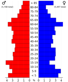
As of the 2020 census, there were 11,256 people, 4,476 households, and 2,962 families residing in the county.
There were 4,874 housing units at an average density of 11.2 inhabitants per square mile (4.3/km2).
There were 5,047 housing units at an average density of 11.6 inhabitants per square mile (4.5/km2).
28.70% of all households were made up of individuals, and 15.40% had someone living alone who was 65 years of age or older.
Watowan's public citizenry of voters have tended to vote for the Republican Party; in two-thirds of the past 11 presidential elections years since 1980, the majority of county voters had selected the Republican Party's presidential and vice presidential nominees (as of 2020).
But there are active party organizations and groups for both Republican, Democratic-Farmer-Labor and independent unaffiliated voting citizens of both conservative and liberal / progressive views.