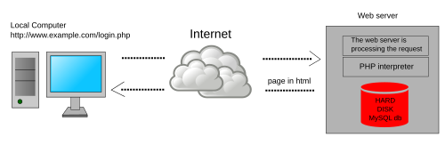
Web GIS
[5] The use of the Web has dramatically increased the effectiveness of both accessing and distributing spatial data, two of the most significant challenges of desktop GIS.
[1][15] The US federal government made the TIGER Mapping Service available to the public in 1995, which facilitated desktop and Web GIS by hosting US boundary data.
[1][16] In 1996, MapQuest became available to the public, facilitating navigation and trip planning, which quickly became a major utility on the early Web.
In 2014, ArcGIS Online replaced this, and offers significant Web GIS functions including hosting, manipulating, and visualizing data in dynamic applications.
[18] Diverse industries and disciplines, including mathematics, history, business and education can all leverage Web GIS to integrate geographic approaches to data.
[18] The United States Census Department extensively uses Web GIS to distribute its boundary data, such as TIGER files, and demographics to the public.
[18][21] Using story maps and dashboards allows for new ways of displaying spatial data, and facilitates student interaction.
[18] As Web GIS tools are often user friendly, teachers can create their own visualizations for the classroom, or even have students make their own to teach geographic concepts.
[22] During the COVID-19 Pandemic, dashboard Web GIS Apps were popularized as a template for displaying health data by Johns Hopkins University, which was updated until March 10th, 2023.
Providing a wide use of OGC standards by different web services, sharing distributed data of multiple organizations becomes possible.
Thus the development of a web-based GI system requires several useful XML encodings that can effectively describe two-dimensional graphics such as maps SVG and, at the same time, store and transfer simple features GML.
[31] This vision requires the definition of geospatial ontologies, semantic gazetteers, and shared technical vocabularies to describe geographic phenomena.
While traditionally trained ethical cartographers try to minimize these errors and document the known sources of error, including where the data originated, Web GIS facilitates the creation of maps by non-traditionally trained cartographers and, more significantly, facilitates the rapid dissemination of their potentially erroneous maps.
[16][14][34] While this democratization of GIS has many potential positives, including empowering traditionally disenfranchised groups of people, it also means that a wide audience can see bad maps.
[33] This has significant implications, and contributes to the infodemic surrounding many topics, including the spread of potentially misleading information on the COVID-19 pandemic.
[24] This phenomenon can lead to previously available data being lost due to users changing the URL, physical hardware failures, or the content being deleted by the publisher.
If the hardware and information accessed within a Web GIS is lost, "a single disk failure could be like the burning of the library at Alexandria.