Wells Gray-Clearwater volcanic field
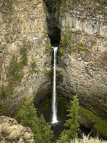
[4] This 5,405 km2 (2,087 sq mi) park was established in 1939 to protect Helmcken Falls and the unique features of the Clearwater River drainage basin, including this volcanic field.
[6] The emplacement of these lava flows spanned at least three periods of glaciation, evidence for which is preserved in the form of tuyas, ice-ponded valley deposits, and subglacial mounds.
[4] Its first phase of activity was involved with water, possibly dammed by glacial ice which filled the Clearwater River valley.
[7] In some places glacial till and fluvial sands and gravels are maintained under the several lava flows that form the volcanic field.
[6] Glaciation has left a thick blanket of till over nearly all of the volcanic deposits and therefore outcrop is largely limited to cliffforming exposures in several valleys.
[6] Lava flows from the two cinder cones lie on glaciated bedrock without an intervening paleosol, indicating an early Holocene age.
[8] More recent studies by volcanologists associated with the Geological Survey of Canada have indicated that the subducted extension of the Nookta Fault may be the primary cause of the alkalic structure of the Wells Gray-Clearwater volcanic field.
[8] Similarly, if the displacement had a section of extension, a horizontal slab window-like gap would have developed, again allowing a pathway for upwelling magma.
[8] In either case, the unsettled asthenosphere might have experienced low degrees of decompressional melting and interacted with North American lithosphere to yield within plate compositions.
[8] The composition of some lava flows in the Wells Gray-Clearwater volcanic field is unusual because they include small, angular to rounded fragments of rock called nodules and crystals that come from the mantle.
[11] Seismic data suggests that these volcanoes still contain living magma plumbing systems, indicating possible future eruptive activity.
[12] Although the available data does not allow a clear conclusion, these observations are further indications that some of Canada's volcanoes are potentially active, and that their associated hazards may be significant.
[3] Beneath areas of monogenetic cinder cone activity, such as the Wells Gray-Clearwater volcanic field, the seismicity appears to be more dispersed.
[4] Such eruptions consist of ejection of incandescent cinder, lapilli and lava bombs to altitudes of tens to hundreds of metres.
[15] The existing network of seismographs has been established to monitor tectonic earthquakes and is too far away to provide a good indication of what is happening beneath the volcanic field.
[15] While there is a likelihood of Canada being critically affected by local or close by volcanic eruptions argues that some kind of improvement program is required.
[3] At present no hazard maps have been created for the Wells Gray-Clearwater volcanic field because the level of knowledge is insufficient due to its remoteness.
Current knowledge is best established at the Mount Meager massif and is likely to rise considerably with a temporary mapping and monitoring project.
[3] With increasing distance and declining numbers of seismographs used to indicate seismic activity, the prediction capability is reduced because earthquake location accuracy and depth decreases, and the network becomes not as accurate.
[3] The inaccurate earthquake locations in the Wells Gray-Clearwater volcanic field are a few kilometers, and in more isolated northern regions they are up to 10 kilometres (6.2 mi).
[3] At carefully monitored volcanoes both the located and noticed events are recorded and surveyed immediately to improve the understanding of a future eruption.