Werribee, Victoria
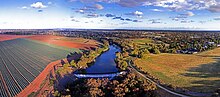
The suburb is situated on its namesake the Werribee River, approximately halfway between Melbourne and Geelong, on the Princes Highway.
Werribee is part of the Greater Melbourne metropolitan area and is included in the capital's population statistical division.
[3] Early leasing of pastures was led by members of John Batman's Port Phillip Association.
The name derived from a suggestion by the owner of a local village inn, Elliott Armstrong, who sought to honour Scottish soldier Sir Henry Wyndham.
[5] The Shire at the time was quite large; extending from the inner Western suburbs of Melbourne to Little River to the northward town of Melton, covering 715 square kilometres.
Thomas Chirnside, a person famous in this area even today, was attracted to the open plain's suitability for agricultural uses.
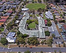
From 1923 to 1973, Chirnside's property was the site of Corpus Christi College, the seminary of the Catholic Church for Victoria and Tasmania.
Werribee is surrounded by several mostly residential suburbs: Wyndham Vale to the north-west, Hoppers Crossing and Tarneit to the north, Truganina and Williams Landing to the north-east, and Point Cook to the east.
The market gardens and well-known tourist precinct are found in Werribee South, on the other side of the Maltby Bypass.
V/Line services to and from Geelong ceased in mid 2015 due to the completion of the Regional Rail Link which sees trains diverted out towards Wyndham Vale.
Tertiary education is Provided by a number of university and TAFE campuses, which are all located in the Werribee Employment Precinct – a large area between the Princes Highway and Freeway.