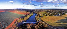
Werribee River
The headwaters of a tributary, the Lerderderg River, are north of Ballan near Daylesford and it flows across the basalt plain, through the suburb of Werribee to enter Port Phillip.
The spelling changed to the present form of Werribee, the original Aboriginal root word meaning spine or backbone.
[1] Before the arrival of settlers, the Werribee River was the boundary of the Bunurong tribe whose six clans lived along the Victorian coast across the Mornington Peninsula, Western Port Bay to Wilsons Promontory.
In the late 1830s and 1840s, the Werribee River was the scene of conflict between the Wautharong people and the European colonisers.
These supply irrigation water to horticultural and vegetable farming users in Bacchus Marsh and Werribee South.