Outer Hebrides
The Gaelic language, religion, music and sport are important aspects of local culture, and there are numerous designated conservation areas to protect the natural environment.
[7] Other early written references include the flight of the Nemed people from Ireland to Domon, which is mentioned in the 12th-century Lebor Gabála Érenn and a 13th-century poem concerning Raghnall mac Gofraidh, then the heir to the throne of Mann and the Isles, who is said to have "broken the gate of Magh Domhna".
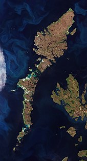
Lewis and Harris has an area of 2,178.98 square kilometres (841 sq mi)[9] and is the largest island in Scotland and the third-largest in the British Isles, after Great Britain and Ireland.
[32][33] Nationally important populations of breeding waders are present in the Outer Hebrides, including common redshank, dunlin, lapwing and ringed plover.
On 4 May 1746, the "Young Pretender" Charles Edward Stuart hid on Eilean Liubhaird with some of his men for four days whilst Royal Navy vessels patrolled the Minch.
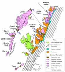
[62] These rocks are largely igneous in origin, mixed with metamorphosed marble, quartzite and mica schist and intruded by later basaltic dykes and granite magma.
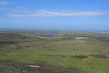
[12][66][67] The Outer Hebrides have a cool temperate climate that is remarkably mild and steady for such a northerly latitude, due to the influence of the North Atlantic Current.
According to the writer W. H. Murray if a visitor asks an islander for a weather forecast "he will not, like a mainlander answer dry, wet or sunny, but quote you a figure from the Beaufort Scale.
"[69] There are gales one day in six at the Butt of Lewis and small fish are blown onto the grass on top of 190 metre (620 ft) high cliffs at Barra Head during winter storms.
[73][74][75][76] Cladh Hallan on South Uist, the only site in the UK where prehistoric mummies have been found, and the impressive ruins of Dun Carloway broch on Lewis both date from the Iron Age.
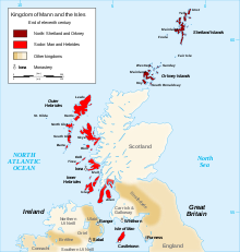
[84] Viking raids began on Scottish shores towards the end of the 8th century AD and the Hebrides came under Norse control and settlement during the ensuing decades, especially following the success of Harald Fairhair at the Battle of Hafrsfjord in 872.
[85][86] In the Western Isles Ketill Flatnose was the dominant figure of the mid 9th century, by which time he had amassed a substantial island realm and made a variety of alliances with other Norse leaders.
His skald Bjorn Cripplehand recorded that in Lewis "fire played high in the heaven" as "flame spouted from the houses" and that in the Uists "the king dyed his sword red in blood".
[90] Following the ill-fated 1263 expedition of Haakon IV of Norway, the Outer Hebrides along with the Isle of Man, were yielded to the Kingdom of Scotland a result of the 1266 Treaty of Perth.
[92] As the Norse era drew to a close the Norse-speaking princes were gradually replaced by Gaelic-speaking clan chiefs including the MacLeods of Lewis and Harris, the MacDonalds of the Uists and MacNeil of Barra.
[89][93][Note 4] This transition did little to relieve the islands of internecine strife although by the early 14th century the MacDonald Lords of the Isles, based on Islay, were in theory these chiefs' feudal superiors and managed to exert some control.
[97] The growing threat that Clan Donald posed to the Scottish crown led to the forcible dissolution of the Lordship of the Isles by James IV in 1493, but although the king had the power to subdue the organised military might of the Hebrides, he and his immediate successors lacked the will or ability to provide an alternative form of governance.
The British government's strategy was to estrange the clan chiefs from their kinsmen and turn their descendants into English-speaking landlords whose main concern was the revenues their estates brought rather than the welfare of those who lived on them.
[106] The position was exacerbated by the failure of the islands' kelp industry, which thrived from the 18th century until the end of the Napoleonic Wars in 1815[107] and large scale emigration became endemic.
Lady Gordon Cathcart took legal action against the "raiders" but the visiting judge took the view that she had neglected her duties as a landowner and that "long indifference to the necessities of the cottars had gone far to drive them to exasperation".
[132] Some of the larger islands have development trusts that support the local economy and, in striking contrast to the 19th and 20th century domination by absentee landlords, more than two thirds of the Western Isles population now lives on community-owned estates.
The Western Isles, including Stornoway, are defined by Highlands and Islands Enterprise as an economically "Fragile Area" and they have an estimated trade deficit of some £163.4 million.
[136] The UK’s largest community-owned wind farm, the 9MW Beinn Ghrideag, a "3 turbine, 9MW scheme" is located outside Stornoway and is operated by Point and Sandwick Trust (PST).
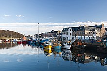
[137][138][139] The Isle of Lewis web site states that Stornoway's sheltered harbour has been important for centuries; it was named Steering Bay by Vikings who often visited.
During the 2014 Scottish independence referendum the area voted against independence by a margin of 53.42% (10,544) to 46.58% (9,195) in favour on a turnout of 86.2%[154] In 2022, as part of the Levelling Up White Paper, an "Island Forum" was proposed, which would allow local policymakers and residents in the Outer Hebrides to work alongside their counterparts in Shetland, Orkney, Anglesey and the Isle of Wight on common issues, such as broadband connectivity, and provide a platform for them to communicate directly with the government on the challenges island communities face in terms of levelling up.
The archipelago is exposed to wind and tide, and lighthouses are sited as an aid to navigation at locations from Barra Head in the south to the Butt of Lewis in the north.
[170] Annie Jane, a three-masted immigrant ship out of Liverpool bound for Montreal, Canada, struck rocks off the West Beach of Vatersay during a storm on Tuesday 28 September 1853.
[171] The tiny Beasts of Holm off the east coast of Lewis were the site of the sinking of HMS Iolaire during the first few hours of 1919,[172] one of the worst maritime disasters in United Kingdom waters during the 20th century.
[178] Fèis Bharraigh began in 1981 with the aim of developing the practice and study of the Gaelic language, literature, music, drama and culture on the islands of Barra and Vatersay.
[178] Outdoor activities including rugby, football, golf, shinty, fishing, riding, canoeing, athletics, and multi-sports are popular in the Western Isles.