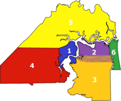
Neighborhoods of Jacksonville
They are the Urban Core, comprising Downtown Jacksonville and some urban neighborhoods to the north; Greater Arlington/Beaches, including the Arlington area north of Beach Boulevard as well as the parts of the Beaches within the Jacksonville city limits; Southeast, corresponding to the Southside area south of Beach Boulevard; Southwest, consisting of the southern Westside; Northwest, comprising areas to the north and west of the Urban Core; and Northside, representing the northernmost parts of the county.
The area that became downtown Jacksonville was on the north bank of a crossing on the St. Johns River known as Wacca Pilatka to the Seminole and as the Cow Ford to the British.
By 1821 a small community had grown there, and local residents plotted out the streets for a town, which they soon named "Jacksonville" after Andrew Jackson.
The part of LaVilla north of Adams Street was for many years a center of African-American life and culture in Jacksonville.
The southern part of the neighborhood was a major railroad hub, with several rail lines meeting at Union Station (now the Prime F. Osborn III Convention Center), and probably not coincidentally, was also for a period Jacksonville's primary red light district.
Over the next several decades LaVilla saw the growth of a burgeoning music and entertainment scene, and many nationally renowned artists came to play at the local clubs on and off Ashely Street that catered to black audiences.
The railroad industry declined and urban decay set in, and after the end of segregation many residents left to seek opportunities in other neighborhoods.
[9] The Southbank is a mixed-used district directly across the St. Johns River from the Downtown Core, closely associated with Jacksonville's San Marco neighborhood.
After the war, a group of investors purchased the southern part of Miles Price's plantation to develop as a new residential suburb.
Growth continued through the early 20th century, resulting in one of the most varied architectural landscapes in Florida, including what is likely the largest collection of surviving bungalow houses in the state.
However, after being designated a "National Historic Neighborhood", by the late 1990s, Riverside had recovered, with many homes restored to their original form.
[14] Avondale is known for its quiet, tree-lined residential streets and hundreds of quaint homes, most dating from the early 1920s during the Great Florida Land Boom.
Springfield became home to many of Jacksonville's wealthiest residents, and boomed following the Great Fire of 1901, with many lavish houses being built.
However, many of its shops were destroyed in a 1969 riot that started when a white cigarette salesman shot a black man he said was robbing his truck.
San Marco remains a diverse and architecturally significant neighborhood, with many of its former government buildings and homes surviving.
[21] The southern border of San Marco ends at Greenridge Road, where the historic Red Bank house sits on the cape of Point La Vista.
The history of the area includes a number of interesting characters: botanist William Bartram; highwayman and cattle rustler Daniel McGirt; and Don Juan McQueen, who attempted to establish a plantation on his 1791 Ortega land grant, but was forced to leave due to attacks of Georgians and the French.
Gangster George "Machine Gun" Kelly and his wife were rumored to be the mysterious couple who abruptly left their rented Grand Avenue home hours before a midnight police raid in 1933.
Ortega, with its giant oaks, waterfront mansions, and series of parks is widely considered one of the most beautiful residential areas of Northeast Florida.
After the Civil War was the summer home of author Harriet Beecher Stowe, whose book Palmetto Leaves was inspired by her experiences there.
It refers to the large section of Jacksonville west of Downtown and the interior neighborhoods, including both populated areas and a vast tract of undeveloped land.
[40][41] Originally established by the 1920s with its main commercial center at San Juan Avenue and Blanding Boulevard dating back to at least 1906,[42] Lake Shore is immediately south of Murray Hill, Riverside and Avondale, Fishweir Creek, and is bound by the Cedar River (called Cedar Creek by locals) to the west and south.
South of Park Street, situated at the southwestern stretch of Avondale's St. Johns Avenue, spanning nearly a mile between Blanding and Lake Shore Boulevards, Lake Shore Terrace is a collection of mid-century modern homes built on larger lots developed by the Brownett and Fort Building company between 1951 and 1953 just north of San Juan Avenue Florida State Road 128.
[43] Bisected by the northern end of State Road 21 (Blanding Boulevard), Lake Shore is home to the Jacksonville Marina Mile which is a regionally unique combination of full service marinas, nautical outfitters, and dry storage facilities that advantageously line the tidal calm of the recreational watercourse on the west bank of McGirts Creek at the confluence of Cedar Creek and the St. Johns River.
Murray Hill is a neighborhood in Jacksonville that is filled with multiple parks, restaurants, bars, community gardens and an art center.
Newer Merchants include: Maple Street Biscuit Company, Community Loaves, and Moon River Pizza.
It is also home to the Murray Hill Farmer's Market started by Nadia Korths and Miranda Jayde Anderson.
By the 21st century the neighborhood showed many signs of urban decay, plagued by crime, failing schools, health issues and endemic poverty.
After the destruction of Fort Caroline, the area was only sparsely inhabited until the 19th century, when sawmills and plantations were established along the St. Johns River.
[50] The Sandalwood neighborhood began developing in the spring of 1960, midway between downtown Jacksonville and the beaches, or about 6 miles (9.7 km) from each, was advertised in 1960-61 as "On the Southside - halfway between business and pleasure!"