Wilkins Sound
Its northern portion was first seen and roughly mapped in 1910 by the French Antarctic Expedition under Jean-Baptiste Charcot and was observed from the air in 1929 by Sir Hubert Wilkins.
Searle of Falkland Islands Dependencies Survey (FIDS) by examination of air photos taken by the 1947–48 Ronne Antarctic Research Expedition.
In 1993, Professor David Vaughan of the British Antarctic Survey (BAS) predicted that the northern part of the Wilkins ice shelf was likely to be lost within 30 years if climate warming on the Peninsula were to continue at the same rate.
[2] A study by the National Academy of Sciences in 2002 stated, "Because air temperatures are statistically increasing along the Antarctic Peninsula region, the presence of glacial meltwater is likely to become more prevalent in these surface waters and continue to play an ever-increasing role in driving this fragile ecosystem."
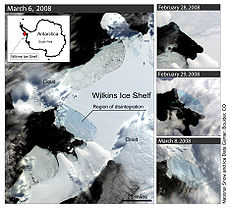
[7] On 29 November 2008, the European Space Agency (ESA) announced that the Wilkins Ice Shelf has lost around 2,000 square kilometres (770 sq mi) so far in 2008.
A satellite image captured 26 November 2008 shows new rifts on the ice shelf that make it dangerously close to breaking away from the strip of ice—and the islands to which it is connected, the ESA said.
The shelf was then only held up by a very thin strip of ice (varying from 2 km to 500 meters at the narrowest), which made it very vulnerable to cracks and fissures.
[10] Satellite evidence from 2 April 2009 led ESA analysts to conclude that the collapse of the strip (which would result in a partial break-away from the Antarctic Peninsula) was "imminent".